Surinovi Bolo Pass
Surinovi Bolo Pass
Description: 3660 meters, steep but over easy open terrain. Livestock graze right up to the top of the pass. Local shepherds and others do not go through this pass – they stay on their own sides.
Name: Surinovi Bolo Pass. Named for the gorge on the western side. Translation: ‘nov’ is Soghdian for gorge (‘dara’ in Tajik), ‘bolo’ is upper/above and ‘sur/suri’ is probably a Soghdian placename or an adjective. Russian mountain climbers, who didn’t know its local name, designated this as “Shkolny Pass” or “School Pass“ in Russian (Перевал Школьный).
Why do this pass? It’s the best/easiest way to connect the Padask gorge to the upper Valighond gorge (Ti Shakh and Sharakho gorges). This is a pass you can do with very little planning. The main route is on the map (any map app that uses Open Street Map data).
GPS track: Download. Note that this GPX track only includes the ascent from the west. I do not have a track for the east side descent as I went exploring along the main ridge before descending (in a very rough area you should avoid).
How long will it take? It took me 5 hours and 30 minutes to get from the bottom to the top (Padask River to the pass). I was moving slowly as I had a stomach illness. I think 4 hours is possible for a very fast hiker travelling light. The descent will be much, much quicker.

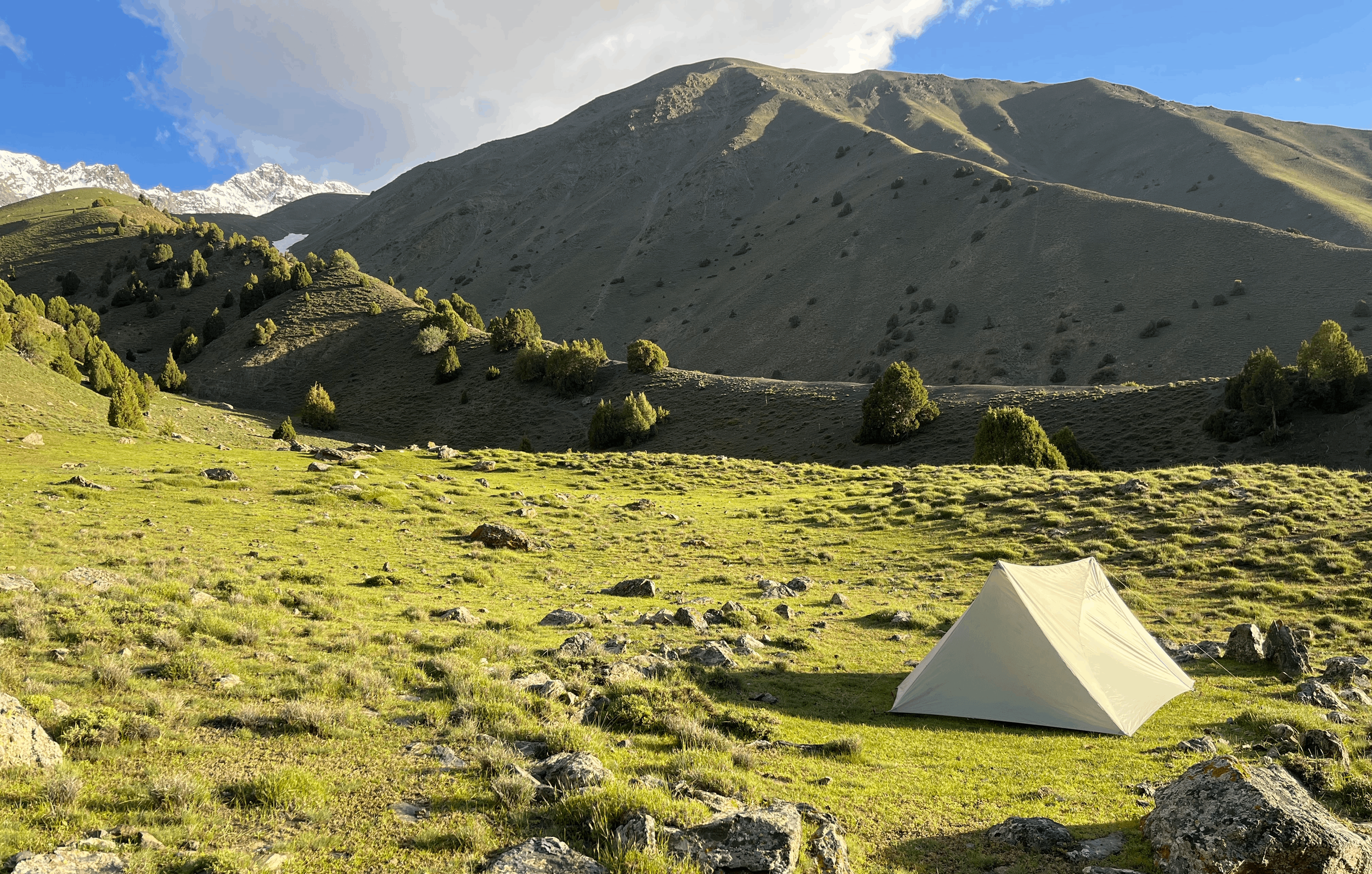
Surinovi Bolo Pass (3660 meters) in the distance, view from the 3030 meter camp on the west side.
This photo provides a great of example of how photos taken with smartphone cannot be trusted. The standard wide angle lenses on smartphones distorts images and compresses images in the distance (e.g., mountains), making them appear smaller. From the tent to the pass in the distance is a more than 600 meter elevation difference. It will look much steep in person, or in a photo taken with a standard camera lens.
Photo below: the bottom of the Surinov gorge, just above the Padask River. Similar to the photo above, this is steeper in person than the photo show.

Start: Likely you will be coming from the west, after doing the upper Padask gorge trek or being eastbound on the Pamir Trail. You can leave the Padask gorge at two different points. The point where the GPS track above begins is the best starting point (for those who hike the upper Padask gorge). Another start point is downriver at 2570 meters, in between two footbridges. This lower starting point is for anybody who wants to skip the upper Padask gorge (something you do not want to do).
From the start of the GPS track there is one small difficulty: a very steep sidehill with very rough/narrow cattle tracks. If you are uncomfortable with the drop, you may want – very soon after starting the GPS track – to descend to the river and hike along the bank. The upper trail and the riverside trail will eventually join downstream. There is one very short section along the Padask river where you may need to duck under tree branches. There is not exactly a very clear trail all along the river.
On the map you will see two springs along the Padask river. Both have good drinking water. You should fill up here instead of from the Surinov gorge stream, as livestock graze along this stream. Note that the stream in the Surinov gorge disappears underground for a while before reappearing. There is a strong spring below the Surinovi Bolo shepherd camp (2870 meters), but I prefer the springs at 2990 meters (above a shepherd camp is always better than below a shepherd camp when managing water risk).
The turn to the Surinov gorge is very obvious, even without following the GPS track. You will soon see a clear trail that is easy to follow (photo above/left), but there are a few places where the trail splits (according to the cows’ grazing patterns). You will almost always be at or near the bottom of the gorge – sometimes right next to the stream and sometimes just above it.

From the campsites (above 3000 meters) there are no more consistently clear trails in the gorge – but plenty of livestock trails heading in various directions. At times in the upper gorge you will be on a trail (but they usually fade away). The terrain is open and it’s obvious where the pass is. You will notice the route marked on the map is above the bottom of the gorge in the upper reaches. This is because the bottom of the gorge is rocky in an unpleasant way, and just above the gorge are trails through grassy/dirt areas that are easier to walk on (see photo left/above).
Just before the pass is a steep section on soft sandy soil and grass. Pick your own route here. Note that there are two saddles about 150 meters apart (not accurately shown on the topo/contour map), and you want the saddle to the south/right. The pass offers nice views and is a good place for a break (but with no water and no shade).
Overnight camping and water: depending on your schedule and timing, you may want to camp halfway up the Surinov gorge.
The Surinovi Bolo shepherd camp has a shepherd hut and was occupied when I visited at the end of June 2022. Nobody was at camp except for two puppy dogs, but the shepherds returned at the end of the day with their flock. The shepherds invited me to stay the night and have dinner with them, but I was feeling ill (unknown stomach problem) and I preferred to go straight to bed. The best place to camp overnight are the two camp sites marked on the map at 3030 and 3060 meters, just above the 2990 meter springs. The shepherds gave me good info on water: these are the last springs – there is no water until you get to the bottom of the pass on the other side. At a bare minimum you should drink as much as you can and then carry 2 liters (more for a large person, a heavy sweater, a slow mover or a person who uses lots of water to cook).
If you stay the night at one of the campsites you will need to angle back towards the bottom of the gorge (but with minimal elevation loss).
Photo below: The view from the top of the pass, looking south. Surinovi Bolo Pass is the lower saddle, about 150 meters away in the distance. The photographers is standing in the second higher saddle (which leads to a very steep drop on the east side).

The descent: You will head almost straight down to the Sharakho gorge, but first you must angle down (southwards) to get on top of a ridge that you can follow down. The ridge is far more obvious in person than it is looking at the map. The GPS track provided above ends at the pass, but you can follow the route marked on your map app (as long as it’s based on Open Street Map data).
I did not go down this ridge, as I chose to go exploring a more difficult route. But the options are clear: go down the ridge to about 3200 meters or below. At about this elevation you will need to make a decision whether to continue down the ridge or to angle north down into the gorge (name unknown) to get water (see the blue arrow route below). This will be your last chance for water for hours, regardless of what direction you are going (the river at the bottom will be too silty for a filter). There is a small shepherd camp in the gorge, so I expect that you should be able to walk down along the stream (but the satellite image is unclear, and my view in person was form too far away). The terrain nearby towards the bottom of the ridge is wide open, with just a few spots too steep to descend. There is nothing to stop you from getting to the main trail along the Sharakho river.
The blue arrow is the route I suggest when descending to the east from Surinovi Bolo Pass. This allows you to have the best views while descending and to get drinking water from the small side gorge. The main channel of the Sharakho Gorge is too silty. The photographer reached this vantage point by going up the Sharakho Gorge (to the left in this photo) and across one avalanche bridge and one footbridge.

Next destination: Head downriver to the summer village of Sangi Ghavl (if you are in a hurry to get somewhere) or take the scenic route up the Sharakho river, then across its two tributaries and down the opposite side to Sangi Ghavl. From Sangi Ghavl you can either go up to the Ti Shakh Pass, or down the Valighond Gorge to the main road in the Zarafshon valley.
You can quickly get to the summer village of Sangi Ghavl (if your map does not display Sangi Ghavl, but rather “Valighond-Bolo” or no village at all, then replace your map app as it is horribly out of date). Sangi Ghavl is mostly women and girls. I stopped there because local two men had just arrived from their shepherding duties. For all others who don’t have an equal number of women in their group – you should just walk on through without taking any photos. Of course, there are sometimes very insistent grandmothers who try to feed you. They are old enough and authoritative enough to host a strange man – but this varies by local culture.