Moghiyon to Seven Lakes
Via the Suvashi Gorge and over Tarkh Pass to the upper Seven Lakes (Haft Kul)
Seven Lakes (Haft Kul) hike via Suvashi Gorge and Tarkh Pass
Most tourists access Tajikistan’s Seven Lakes (Haft Kul) via the main road through the village of Shing. This involves finding irregular shared transportation to the village of Shing or hiring a private driver. The first is unpredictable, time consuming and frustrating, and the second is expensive. There is, however, an alternative for those who enjoy hiking and are in good shape: a hike from the town of Moghiyon up the Suvashi gorge and then over a pass to the village of Padrud between the 4th and 5th lakes.
Below you can see the video summary of my hike at the end of May 2022.
Alternate routes: There is already a good description of a similar hike on the Adventures of Nicole blog. This hike also goes up the Suvashi gorge from Moghiyon, but it descends to the town of Marghuzor, between the 6th and 7th lakes. This is the route you should take if you plan to go down the Seven Lakes and back to Panjakent. The route I describe is for those who plan to go over Tovasang (Tavasang) pass to eastern destinations: Kuli Kalon, Iskandarkul, Artuch, Alauddin, etc. Note that my route skips the bottom three lakes (my personal opinion is that this is not a big deal, the lakes are small and not particularly remarkable by the standards of Tajikistan’s mountain lakes).
Map and navigation: I have edited and updated all points below in Open Street Maps. This means that it appears immediately on the OsmAnd map app (then paid version with live updates), and anywhere from 1 month to 3 years later on other maps apps. Note that other map apps leave out essential details, such as farmyards, corrals, and shepherd camps. I cannot provide a GPS track as my trip was used to explore off trail and check alternate routes.
On your map app you can set the following route: Moghiyon —> Gandumpoya —> Zindovud —> Tarkh Pass —> Ogul —> Padrud —> Marghuzor —> Hazorchashma
Transportation: It’s best to start in Panjakent. The shared taxis to the trailhead in the village of Moghiyon can be found on Panjakent’s main road, 150 meters south-east of the central bazaar. This is clearly marked (“Moghiyon Shared Taxis”) on any regularly updated app that uses Open Street map data. Here you will find a side street and shared taxis lined up both on the side street and the main street. You will likely be approached by drivers looking to take you on an expensive private tour to the Seven Lakes. Say ‘no thanks’ and ask for the Moghiyon driver(s). Likely you can’t pronounce the ‘gh’ in Moghiyon, but they will perfectly understand ‘Mogiyon.’ The drivers to Moghiyon actually service Moghiyon and the numerous villages and neighborhoods nearby. So specify ‘Moghiyon’ or ‘Mogiyon bazaar’ (on the map it is labelled as “Chorshanbe Bazaar”). I paid 25 Somoni for a seat. This is the local price, and absurdly cheap for a destination in the Fann Mountains. The low price is due to the fact that tourists almost never go to Moghiyon, so the drivers are unaware of the practice of asking 3 to 20 times the local price. 25 Somoni is $2.50 at 2022 exchange rates, so when you go, check what $2.50 is at the current exchange rate. Also, expect the price to rise (in USD and Somoni), as the future of energy prices in Tajikistan appears bleak.
The drive is 50km, and the second half is on rough dirt roads. The route will be the same as the route to Shing and the lower lakes, until the final 3rd of the journey when you leave the road in the gorge and head up to Moghiyon. The road is steep and slow, with views of a massive gold mine on the opposite side of the valley. Your driver may drop people off in front of their houses in neighboring villages, so don’t be alarmed if he leaves the main roads and goes “the wrong way.”
Accommodation in Moghiyon
The Moghiyon drivers never see foreigners, so I was invited for tea and the driver’s house (he insisted numerous times). This of course turned into a snack, and then a meal and another meal until he declared that was too late to start hiking and that I should stay for the night. This is a very common occurrence when you are not in the most popular tourist areas.
However, I arrived later in the day because I began my trip in Dushanbe. If you stay the night in Panjakent, it makes far more sense to start your hike immediately. But if you do want to stay the night in Moghiyon, there is a guest house supported by the Zarafshan Tourism Development Association: Homestay “Dorob.” This is actually 500 meters from Moghiyon in the neighborhood/village of Foni. You can find information on the ZTDA website.
Note that I did not visit this guesthouse, so I cannot confirm its location as show on a map app that uses Open Street Map data. The location is taken from ZTDA’s website.
For a guest house in a rarely visited location, you are taking a risk with showing up unannounced. I suggest asking ZTDA to make a reservation for you. I have not heard good things about their responsiveness to emails, so I suggest a phone call. When you are on the ground and looking for the guest house (if the map location is not accurate), don’t bother asking for the guest house by it’s name, but rather by the name of the owner: Qodir Bobojonov. He is a well know musician, so you should ask for “Ustod Qodir” (ustod = ‘master,’ and is used for professors, accomplished musicians, professors, etc.)
If you do visit – and the location of the guesthouse is wrong – tap on the OsmAnd map app and (selecting “actions”) then go to “Open OSM Note.” You can then mark the real location and automatically upload that with a note to OSM editors.
The hike
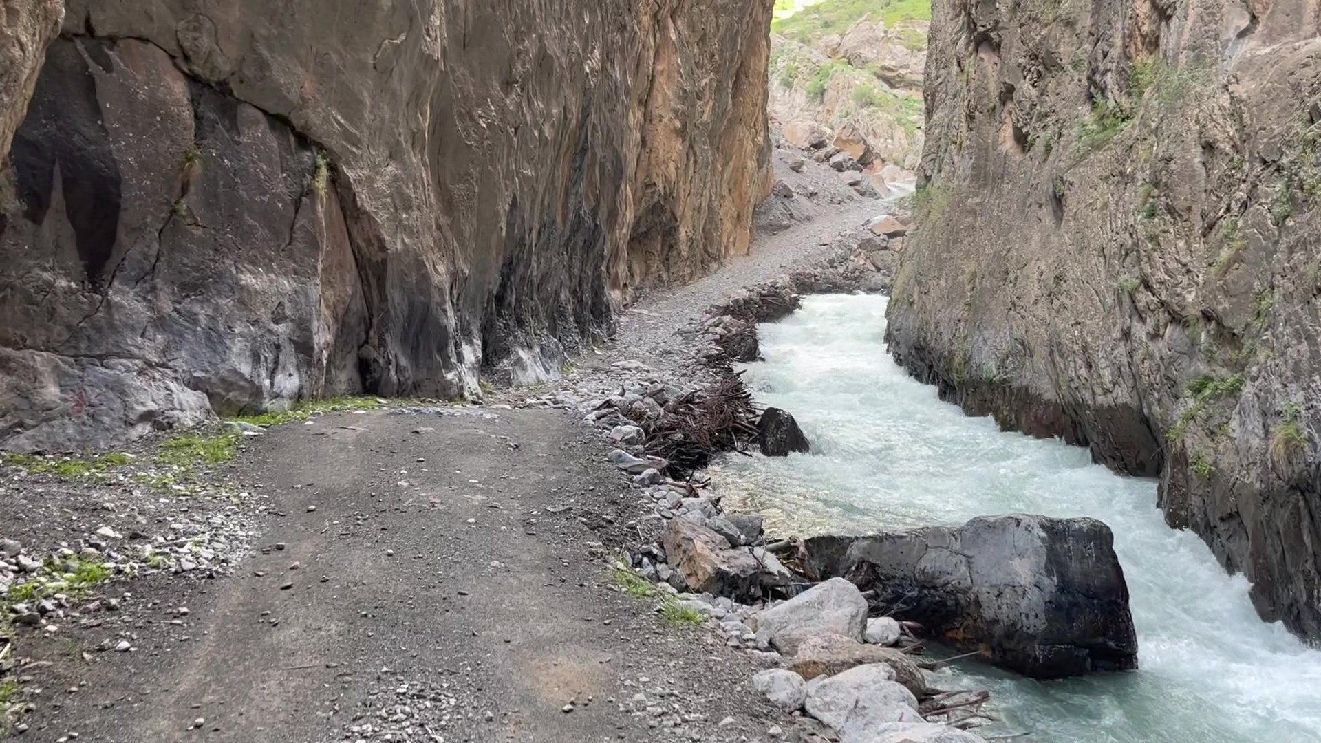
The start of the hike in Moghiyon is pleasant, and the people are generally friendly and curious. You will find a convenience stores, small grocery stores and a small bazaar at the beginning of the hike. When you approach the village of Obi Borik you will walk by two toilets. After Obi Borik you will be entering the gorge.
Technically, you will be hiking on a road. But the road is very narrow, very pleasant and sees almost no traffic. I did not see a car on my hike, and I saw only one set of tires tracks that looked days old. If you start your hike at the end of the day (e.g., you are coming from Dushanbe or Samarkand) then you will likely need to camp for the night. Check out the map for some good camping spots. Outside of the marked camp spots there are places it is possible to pitch a tent, but the spots won’t be as nice.
There is nothing on this lower part of the route route that is technical or worth mentioning as difficult (unless a side stream is flooding). On my trip I saw up to 20 people on foot with some leading donkeys loaded with supplies.
For my route, you will need to leave the main road and turn up towards the mountain villages of Gandumpoya and Zindovud. In this area there will be many splits on the trail that lead towards farming fields or livestock grazing areas. But it’s almost impossible to get lost. You can easily see the route ahead. After passing the final village of Zindovud, you will need to think about you water supplies. I was there in the last week of May when water was plentiful. When passing Zindovud, I would look down into the stream to see if there is water or not. If there is water still, then you can fill up on water before your turn east to ascend to Tarkh Pass (definitely treat/filter your water as there is lots of livestock in this area). How much water? I was fine with drinking as much as I could and then filling up with 2 liters to carry. But a large person who sweats a lot or a very slow hiker may need more.
From Zindovud to the pass is not one single clear trail. There are numerous livestock trails that go in multiple direction. Follow the trail on the map and you will be fine. The territory is wide open and you can pick you own route without getting lost.
Tarkh Pass
Tarkh Pass is not a commonly known name. I got that name from a shepherd up high. But the people in the lower areas referred to the pass by the village on the opposite side of the pass (so in Padrud they just referred to “the pass to Zindovud, and on the western side I was able to make my travel plans clear by saying that I was going to Padrud and Haft Kul).
Just above Tarkh Pass is a summer shepherd village. It was not being used when I was there at the end of May, as shepherds were still in the lower areas.
Expect the pass to be snow free by mid-May in an average year, and by late May in a year following a heavy snowfall winter or a cold spring. If there is snow, there won’t be too much danger. It’s not steep enough in the pass to prevent you from walking through or on snow.
The descent
From Tarkh Pass you will slowly descend to Oguldara Pass (barely a 150 meter drop over a long distance). Beware of numerous livestock trails leading in directions you don’t want to go. From Oguldara Pass you angle over to the high shepherd village of Ogul. If you are out of water, ask in this village as there will certainly be a spring nearby. The universal signal for needing water is to wave an empty plastic water bottle while looking sad.
I did not visit Ogul, but usually these type of shepherd villages are inhabited women and children only, and the men are off with their flocks in higher pastures. I usually walk by (without taking photos are staring) and continue my journey. But in this region it is not uncommon (as a male) for an authoritative old grandmother to call you over and attempt to feed you. If you do get fed, expect bread and sour yoghurt. This is more common in the areas that tourists rarely visit. In the Haft Kul area there are some Luli (Roma/gypsy) communities, and the women and children are not at all shy to talk to unfamiliar men.
The descent to Padrud from Ogul is very steep, but children and the elderly manage, so you should have no serious problems. Look on the map to see your option for skipping Ogul. Reason you may want to skip Ogul: you are tired and just want to get to Padrud, it’s getting late and you don’t want to be delayed by hospitable mountain people, you are scared of shepherd guardian dogs.
Are dogs a problem elsewhere? Not for me. I only saw dogs in the far distance barking at me from their houses. Also, the high camps were still empty. Late I the summer there may be more shepherd up high and therefore more dogs. The dogs just bark, they don’t attack. If there is no shepherd or local nearby to restrain the dog, just go around (the terrain here is open and you can do that). If you do encounter a scary dog, I find that merely pretending to pick up a rock from the ground is enough to scare them off. They also appear to believe that a trekking pole is the same as a heavy wooden shepherd’s staff. They are easy to scare away.
How long will this trek take you? It depends. A fast hiker going lightweight with an early start from Moghiyon can make it to Padrud in one day. I made it in 16 hours (10 hours moving time, 6 hours sitting and enjoying the view) – but with an extra 6-8km detour added, and with 10 days’ worth of food and supplies in my bag (and it being my first hike of the season and being out of shape and not yet acclimatized to altitude). For a medium-fast hiker on the shortest route (about 27km) I would guesstimate it to be a maximum 10-12 hour hike with numerous stops and breaks.
To get the truly early start time you will need to stay the night in Moghiyon. For all others, I suggest a late start and then camping overnight in the Suvashi gorge. Once you leave the Suvashi gorge and then head up to and past the villages of Gandumpoya and Zindovud you will not see any good camping spots (it’s steep, rocky and treeless). Breaking the hike into two days will result in leisurely travel with plenty of time for relaxing and sightseeing.
Compared to other hikes listed on this website, the Moghiyon to Haft Kul trek is very easy (technically and in terms of elevation).
Onward travel: I suggest staying the night in the Mijgon guesthouse in Padrud or the Najmiddin guesthouse in Nofin. From here you can arrange for transportation to Panjakent for the next morning. For those heading up or further into the Fann mountains, you will need to do some road walking. But… look at the map and you will see some trails you can use to skip the roads that take you to the 6th and 7th lakes. These will, however, add time and elevation to your trip. The roads here are neither pleasant nor unpleasant to walk on.
Your destination should be the 7th Lake – Hazorchashma. It’s not a full day hike for a fast hiker, so take your time. I suggest going to the far south end of Hazorchashma lake to camp. The lakeside trail is definitely worth it.
If you are looking to get onto the Pamir trail or just get to Artuch, Kuli Kalon, Alauddin, Chimtarga Pass, Iskandarkul, etc., then you will need to head over the easy Tovasang Pass – 3305 meters (trail begins on the north end of Hazorchashma lake) or over the more challenging Upper Chapdara Pass – 4115 meters (accessed from the south end of Hazorchashma lake), but for this high pass bring crampons and an ice axe in the early season.
For Tovasang Pass (Tavasang in Russian), you can easily find descriptions and reports online. Search these pages for ‘Tavasang’: here or here. Tovasang Pass is set to be part of the Pamir Trail route, so check this page for updates and a more detailed description in the future.
Useful notes: The villages of Marghuzor and Padrud have rarely open convenience stores that sell only snacks and junk food. Don’t plan to resupply here. The guesthouses include dinner and breakfast in the price (about $17 per person, but possibly higher and food/energy prices are increasing), and they both have showers and western toilets.
Last updated: 10 August 2022