Varzob to Ziddi Trek
This report covers the 2-3 day hike from the Varzob gorge just north of Dushanbe to the Ziddi Valley to the north over the eastern Hisor Mountain range (also known as the Sanginavishta range). The starting point is the village of Hushyori and the end point is the village of Ziddi (also known as “Kalon“). The main pass is the Kulol-Sangalt Pass.

The north side of the Hisor Ridge (Sanginavishta Mountains)
Why do this hike?
The starting point is very close to Dushanbe.
It gets you halfway to the Yaghnob Valley, with the section from Ziddi to Yaghnob being much easier.
As an alternate route on the Pamir Trail.
It ends in the village of Ziddi (restock on food, onward car transportation).
Why would you not want to do this hike?
The north side has some snow and ice to cross, especially earlier in the summer. So July may involve some snow travel, some of it in steep areas (meaning crampons and an ice ax are a good idea).
It’s not as spectacular, accessible and easy as the nearby Fann Mountains.
Unclear trail in many locations, especially up high. Rough trails and very rocky in places.
No guesthouses anywhere on this route.
Aggressive shepherd dogs and camps will be more common here than in the Pamirs or the Fann Mountains.
Total isolation on a route that nobody visits (shepherds stay below the grass line, and do not go through the pass).
Alternate routes: The Pamir Trail has a route across this same ridge, but further east. Check their website.
The video above is from a 3-day hike (September 1st to 3rd, 2021). This is a time of maximum snow melt. We only had to walk on an easy and safe short section of the glacier on the north side of the pass. The rest was on rock or trail. Hiking in July or earlier may require crampons and an ice ax.
Trip Report
Location: The hike starts in the village of Hushyori, on the main highway north of Dushanbe. The Pamir Trail also goes through Hushyori, so you may be coming from the Iskandarkul/Saratoq(Sarytag) area (a 6-7 day hike to this point). You should have your map app open to follow the advice and route given below (preferably the OsmAnd map app).
The hike: Minimum two full days of hiking, but probably three.
Transportation: If coming from the Fann Mountains and arriving in Hushyori, you will probably be wanting to go to Dushanbe to restock on food and charge batteries. Go to the southern part of Hushyori along the main road and look for taxi drivers waiting around - or stand by the road and put your hand out (a low wave, not a thumbs up). A single seat should be about 25 Somoni (2021 prices) from Hushyori to the Vodonasos Bazaar. This is where the local drivers will be going. But if you hitch a ride from someone just passing through, they may be headed for the western part of Dushanbe, and away from the center (where most tourist accommodation is). To hire a local driver to leave immediately (e.g., not in a shared ride with other people), expect to pay about 100 Somoni to Vodonasos Bazaar (2021 price, to adjust for weakening Somoni, consider the price to be $10). Once you arrive in the Vodonasos area, go to the southwest corner of the main intersection (in front of the #185 building on the map). Here you will find shared taxis with a #3 sign in their windows (or just holding up 3 fingers at you). Current price (early 2022): 7 Somoni, but just give them 10 since they will have to help you put in and take out your backpack and deal with a dusty, smelly, sweaty mountain traveler. The #3 cars go south all the way along Rudaki Avenue to the train station. Just stay “stop“ when you want to get out. You can walk to many guesthouses, hotels and hostels from Rudaki Avenue. I prefer “City Hostel“ as it is close to Rudaki Avenue and to the “Rudaki Plaza“ supermarket (in the area of the Pedagogical University).
For Dushanbe-to-Hushyori, you can again take the #3 shared taxi, this time going north (just walk to Rudaki Avenue and wave at them when you see the #3). The Vodonasos area is its final destination. Once here, avoid the long-distance drivers (Khujand and Panjkanet) and the tourist drivers (usually yelling “Iskandarkul!“ at you) and walk to the north side of the street across from the Vodonasos Bazaar to the taxi stand marked as “Shared Taxis to Varzob“ on the map. Varzob refers to many destination in the Varzob gorge. You may not find a Hushyori driver, but you will very likely find a driver who will take your 100 Somoni to take you to Hushyori. Note: the locations for drivers/taxis do occasionally change.
Camping: Somewhat awkward, as there are limited good spots for camping (due to the steepness, rockiness and narrowness of the gorge). We did a half-day hike from Hushyori to the 1900 meter camp, and then the next day did a full-day hike through the pass and to the flat grassy area at about 3600 meters (flat, grassy and with good water, but cold). If you stop anywhere in between you will be on a rough, rocky area not well-suited to comfortable sleeping and tent-pitching. This requires a long and fast day, especially later in the summer when the days get shorter.
The Trail (southside): From Hushyori to the shepherd and firewood cutter camp at about 2080 meters is a very clear trail. Afterwards you cross a small footbridge (that may be destroyed and not rebuilt - it doesn’t look like a permanent bridge - you may have to ford the small river). From here you start to hike above the gorge in a forest. There are multiple livestock trails here that appear and disappear and often run parallel to each other. You may be having to push your way through some brush and branches, depending on the route you end up on.
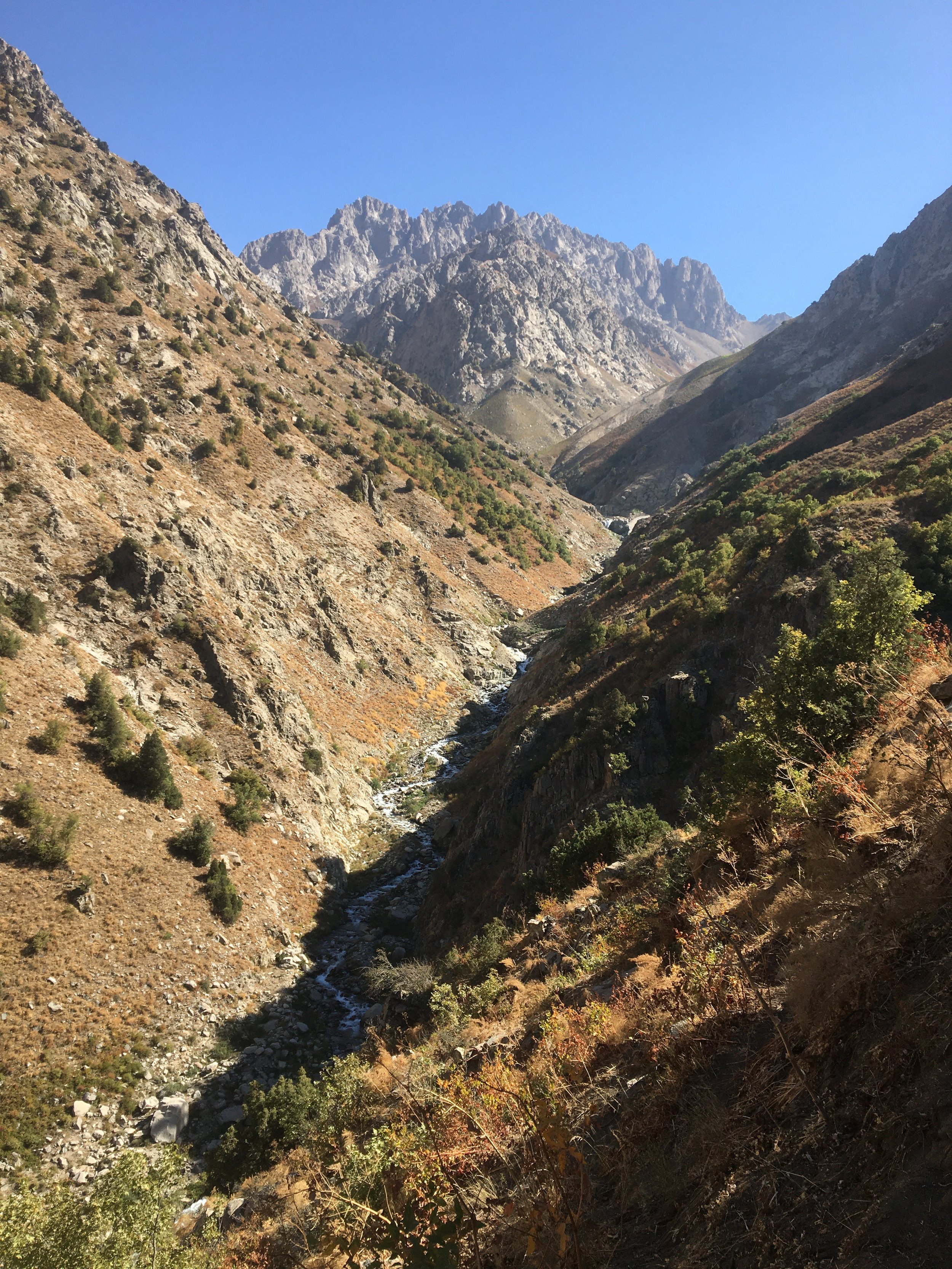
At about 2200 meters, with the forested area ahead. The Pamir Trail goes up the gorge to the right, and our route goes to the left up the main gorge.
By the time you get to the waterfall at 2350 meters, there will be no more trees or brush and the trail will transition to high altitude grassland and low vegetation. Here you will find multiple grazing trails made by the sheep. By 3300 meters it will be mostly open terrain, and the multiple faint trails will be going in directions that you don’t want to be going, as you will be heading straight up to the pass.
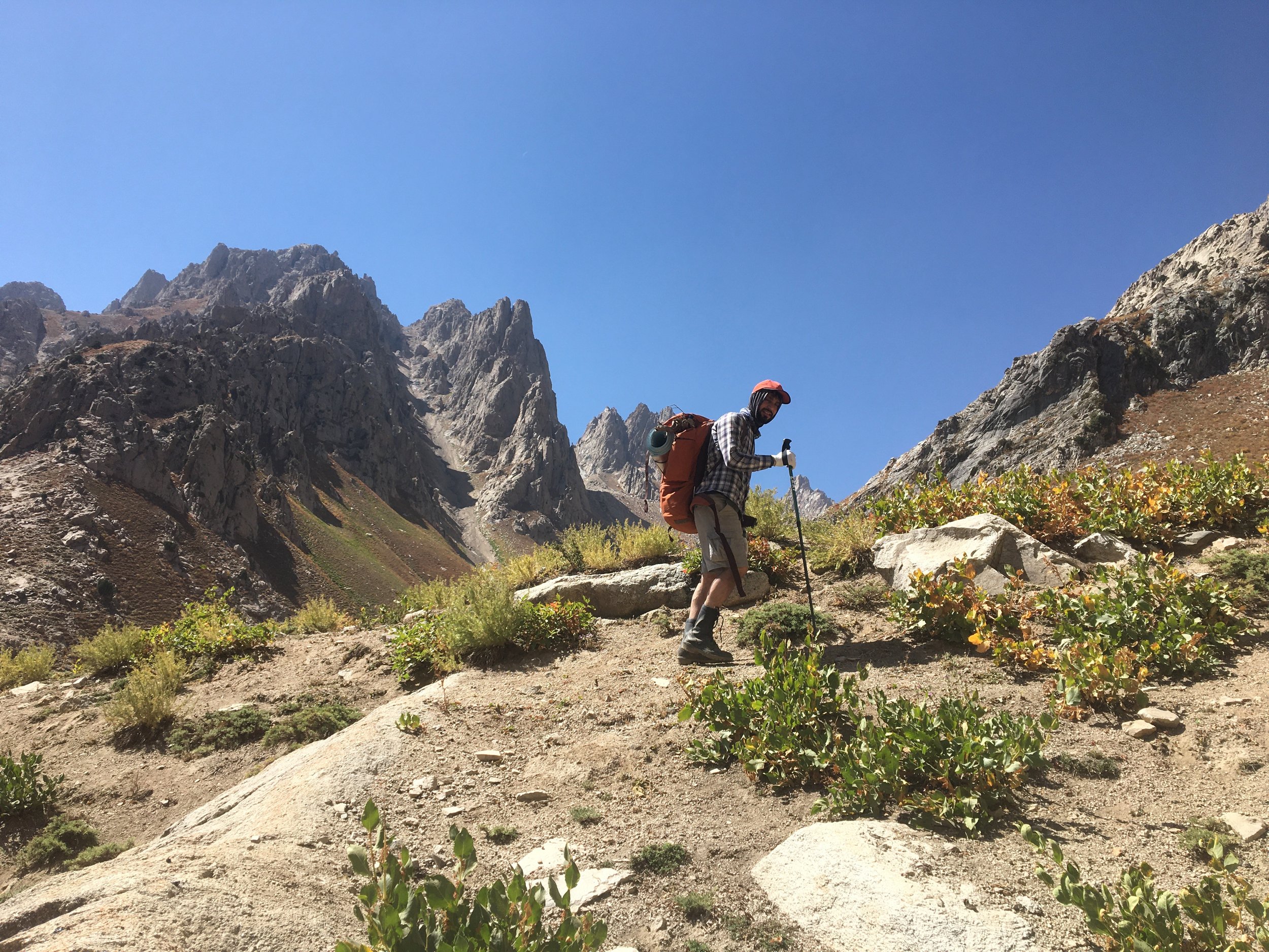
At about 3300 meters.
We saw no shepherd dogs in the first week of September on this hike, as the grass was dried out and already eaten. But there were signs of many sheep having been there recently (probably well into August).
There may possibly be a section with a rockfall danger in the earlier part of the summer (for a couple hundred meters just north of the Kulol-Sangalt Pass). This is a common danger along the Hisor mountain range (same for Mura Pass, and likely also for Dushokha Pass to the east). One trip report is not enough to accurately assess the rockfall danger. Visit at your own risk.
Isolation. You can see the locations of the shepherd camps on the maps. Above the last camps don’t expect to see anybody, as no tourists visit here. And the shepherds leave this area by later summer (we met nobody until we were almost in the village of Ziddi).
The Map
This entire route has been mapped on Open Street Map. So it is a fully clear route on the OsmAnd map app (Android and iOS). Other map apps also use OSM data, but they don’t full integrate all the data into the map. OsmAnd is far superior for use in the mountains of Tajikistan (pay for the $10 upgraded version so that you have the version with updates and the contour lines and hill shading). You can download all of Tajikistan for offline use (using just the satellite GPS signals). The OsmAnd map app has many manual settings, so play around with it for a while to get the appearance and features you want. Note: the hill shading download really helps you to read the terrain once you have set up the contour/topographical/elevation lines.
Your favorite map app from home does not work as well in Tajikistan. All of them (as of 2021/2022) have some sort of fault(s) that present some danger or confusion. They are very out of date or they leave out vital information.
Tajikistan map download on OsmAnd: 51MB; Contour Lines: 625MB; Hillshade: 268MB. It’s best to do this before you get to Tajikistan (while you still have fast internet).
Note that the GPS signal gets unreliable when you are in the steeper/narrow parts of the lower Darai Kulol gorge.
Final notes: I did see at least one empty gun shell at higher elevations. So hunters do visit here. However, hunters usually go out in early winter.
Despite one mountain climber’s claims, this is not any sort of nature preserve, and there are no restrictions on hikers visiting (his further claims that the sheep grazing here and the bridges built by the shepherds are illegal were refuted by a government employee). The same climber posted photos of his own visits to this area. He seems to be motivated by a disdain for ethnic Tajik shepherds and European/American hikers, but he clearly feels that Russians and ethnic-Russians should have full access to this region as their own personal playground. Others clearly ignore him, and more casual day hikers from Dushanbe do visit the lower part of the Darai Kulol gorge, and some people do drive through the coal mine to do some hiking in the Sangalt gorge.
To be clear, I am not referring to the Russian climber who has made the most important contributions to mountain maps for tourists in Tajikistan. He has published many valuable resources (maps and trip reports). Check out his early summer mountaineering trip to this area. There is some small overlap with the route, but most of it is snow/ice mountaineering that is not relevant to a hiker.
The coal mine on the north side may not want you walking through their operation (dangerous) and taking photos (it’s either annoying or makes them paranoid). That’s why there is a route mapped that avoids the mine. The detour is also the scenic and quiet route, to be clear.
Villagers in both Hushyori and Ziddi were very friendly and happy to see us, and they were more than happy to hear about our hike above their villages.