
Shirgovad Pass
Shirgovad Pass
Shirgovad Pass was used historically in what is now Tajikistan to connect the Vanj Valley to Vakhyo, now known as Sangvor District (previously Tavildara District), or known to tourists as Sangvor National Park. No locals have done this pass from the west since a group from Arzing did it in 1996. In 2021 two hikers from France successfully passed through from west to east, but faced several dangers along the way (and used some climbing gear). In August 2025 I attempted a safer version of this route, minus the climbing gear, from the village of Arzing to the village of Shirgovad in the Vanj Valley, but was stopped by a steep moraine left by the receding glacier. A discussion with a local who made the trip in 1996 and his assessment of my photos led to the obvious conclusion: the receding and shrinking glacier has drastically changed this route in certain spots and it may no longer be possible for hikers - even those with climbing skills. Or it may not be that hard if a person can get through the obstacle I turned back at (as in the case of the French hikers).
This report includes my attempt, information from the local people and Soviet-era climbers on this route, as well as some speculation and suggestions for anybody making a future attempt. Follow along my route using this GPX file.
Below is a video of my hike from Arzing until I was blocked at the Siyoh Lozar Glacier. My trip report below will refer to this video with exact time references, so you may want to open the video in a new tab.
Shirgovad Pass is a very challenging hiking route. In short, there were some very dangerous river crossings in late August and the receding Siyoh Lozar Glacier left behind a steep gravel moraine that was not walkable. I turned back at the moraine and did not get a chance to see how the changing glaciers farther along the route have affected a person’s chances of actually getting to Shirgovad Pass itself. However, the French hikers in 2021 did make it through this obstacle. Details further below.
I don’t advise hiking here until the last week of September at the earliest (unless footbridges are built over the rivers). The locals said that the last week of September or the first week of October is when the river crossings become safe – but not all river crossings. A hiker made it from Vanj to Sangvor via the village of Stargh in August 2025, but it involved extensive glacier travel and a very very dangerous crossing of the main Vanjob River (a river that the Shirgovad route avoids crossing). See his short description on Instagram. In a chat group he advised against any and all summer travel due to several very dangerous river crossings. See the Pamir Trail website for a summary of this route (Section 6B), as a group of four did the Starghi Pass route a couple of years ago, but not until the fall when the water levels had dropped. My river crossing experience in late August is discussed below.
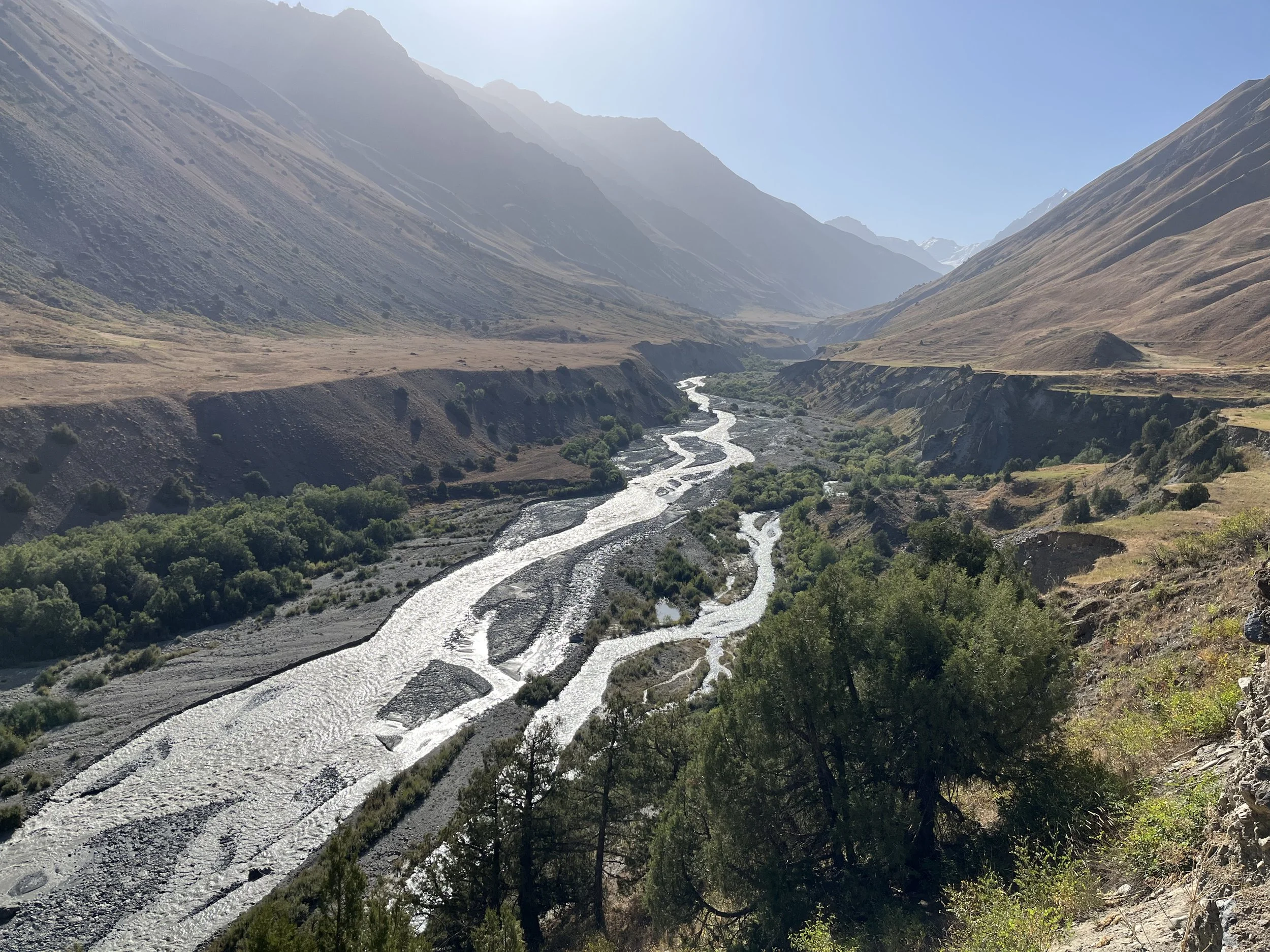
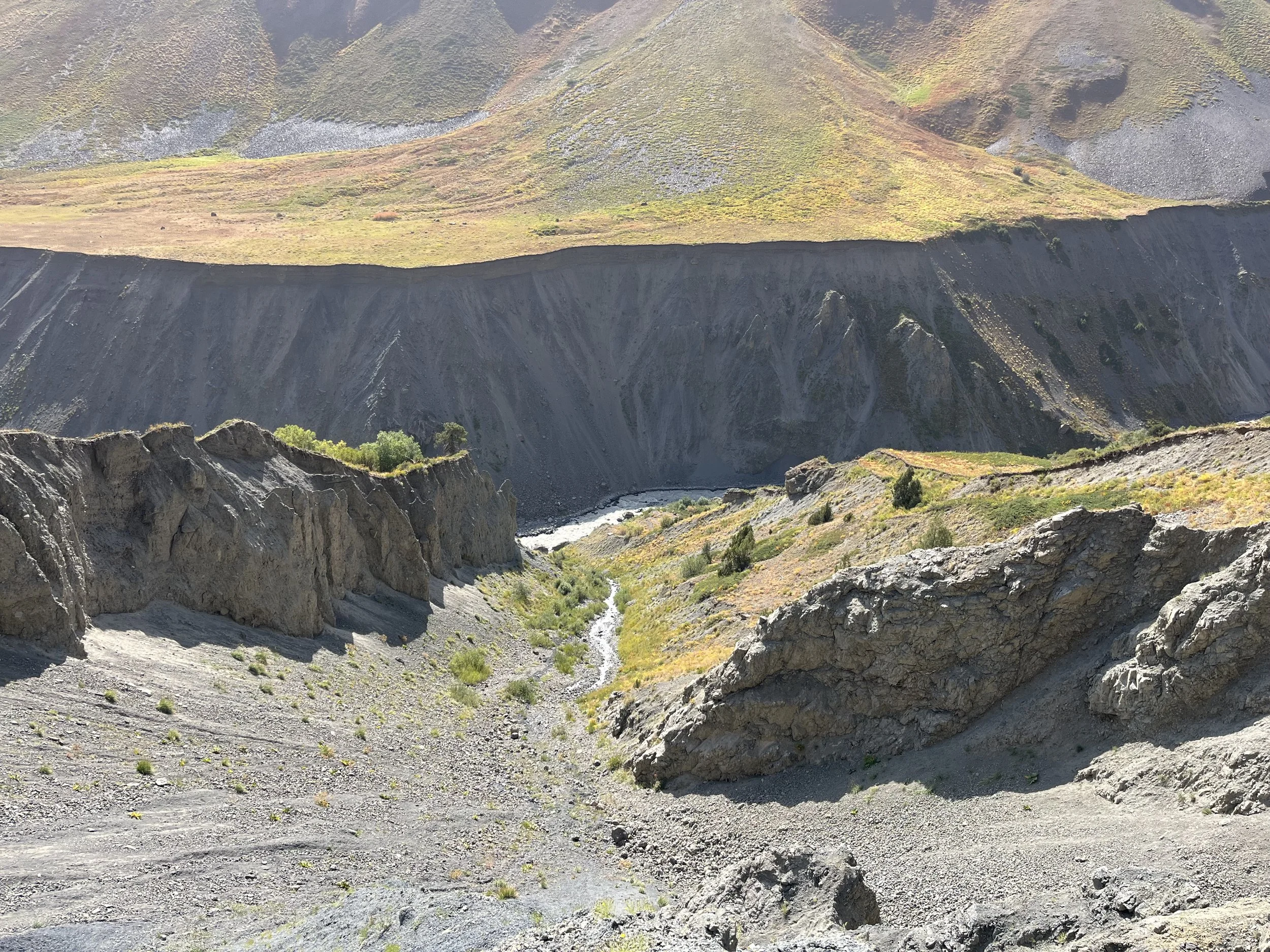
Photo below: The Vanjob River at Dashti Suroysha.
For my partial trail guide, I will describe the route from the west, even though I recommend to attempt the route from the east for reasons I will give further below.
From the west, you start your hike in Arzing, but first you need to check in with the head ranger either at the main park headquarters (coordinates: 38.90154 70.97782) or up the road at his house in the village of Langar. Everybody here knows him and where his house is. Ask for him by his name - Munir Chobirov. Unfortunately, sometimes the park HQ is not manned and he is not at home. So you may have to waste a full day waiting for him. For my first trip to this area I was unable to find anybody over several days.
On the main road there are at least two police checkpoints where you need to register. Here they will at a bare minimum take a photo of your passport, or in my case also take a photo (police mugshot style with hat removed) and slowly write down all your information. You will need to be able to speak Russian or Tajik to relay all of this information. If not, then I guess they will just take a photo of your passport. The first was on the road between Langar and Lojurg (coordinates: 38.87826 71.09508), and the second was in the village of Rogha (coordinates: 38.85100 71.32440).
If you need to purchase food, the village of Sangvor has a small store with the following items: ramen, pasta, peanuts, pistachios, candy covered peanuts, apricot pit nuts, almonds in shell, other nuts, corn nuts, raisins, plain biscuits that are not too sweet, and assorted candy, plus RC Cola and some juice. Farther downriver in the village of Lojurg there are two food stores, but I didn’t visit those.
Note that Megafon is the mobile phone provider here, but as of 2025 the signal dies before you reach Arzing, right after the village of Rogha. There is no connection to the electric grid in Arzing. So there are no electric outlets in people’s homes. They have solar panels and batteries.
The start of the trail
On 21 August 2025 at 650am I started walking from Arzing and crossed the footbridge over the Khingov River (0:34 in the video above). It is relatively new and does not appear on out-of-date satellite imagery. In Arzing you make your way to the bridge over the Khingov River after walking through and around farm fields and grazing areas. The route is approximate and may change. But it’s mostly open terrain you can make your way through easily.
Immediately on the other side you are presented with a trail that appears and disappears. Just make your way upriver – you can’t get lost with the river on one side and the mountain on the other. Eventually the route is squeezed tightly between the mountain and a river channel and it becomes an unpleasant trail. It is not well built and maintained as it is only really used twice per year: once to bring the cows to pasture and once to bring them back at the end of the season. But don’t worry, the route will get more pleasant.
The route soon disappears and the cattle route is actually on the dried riverbed below, which makes for easy walking across gravel and sand. Note that this will be flooded in the early melt season.
Before you get to the Nusay River crossing you will walk across some very nice flat grass meadows. This would be a nice place to camp if you want to cross the river at the earliest time of day before the glacier melt raises the water levels. If you are camping, bring all the water you need as there is only a very silty river here.
The Nusay River was incorrectly labelled as the Bijou River for many years. So you may find some old anecdotes about the Bijou River crossing online that are actually referring to the Nusay River. And yes, there is also an Obi Nusay River on the opposite style of the ridge, as is not uncommon in Tajikistan. The actual Bijou is not a river, but a small stream you can easily step over (downriver from the bridge crossing, and not on this route). I have made the change in Open Street Map as of mid-October 2025. Some out-of-date map apps may not show this change.
The Nusay River blocked a Pamir Trail team in 2021. Link to story here (note that the story uses the old incorrect name Bijou for the Nusay River). You can see that they had higher water than I did.
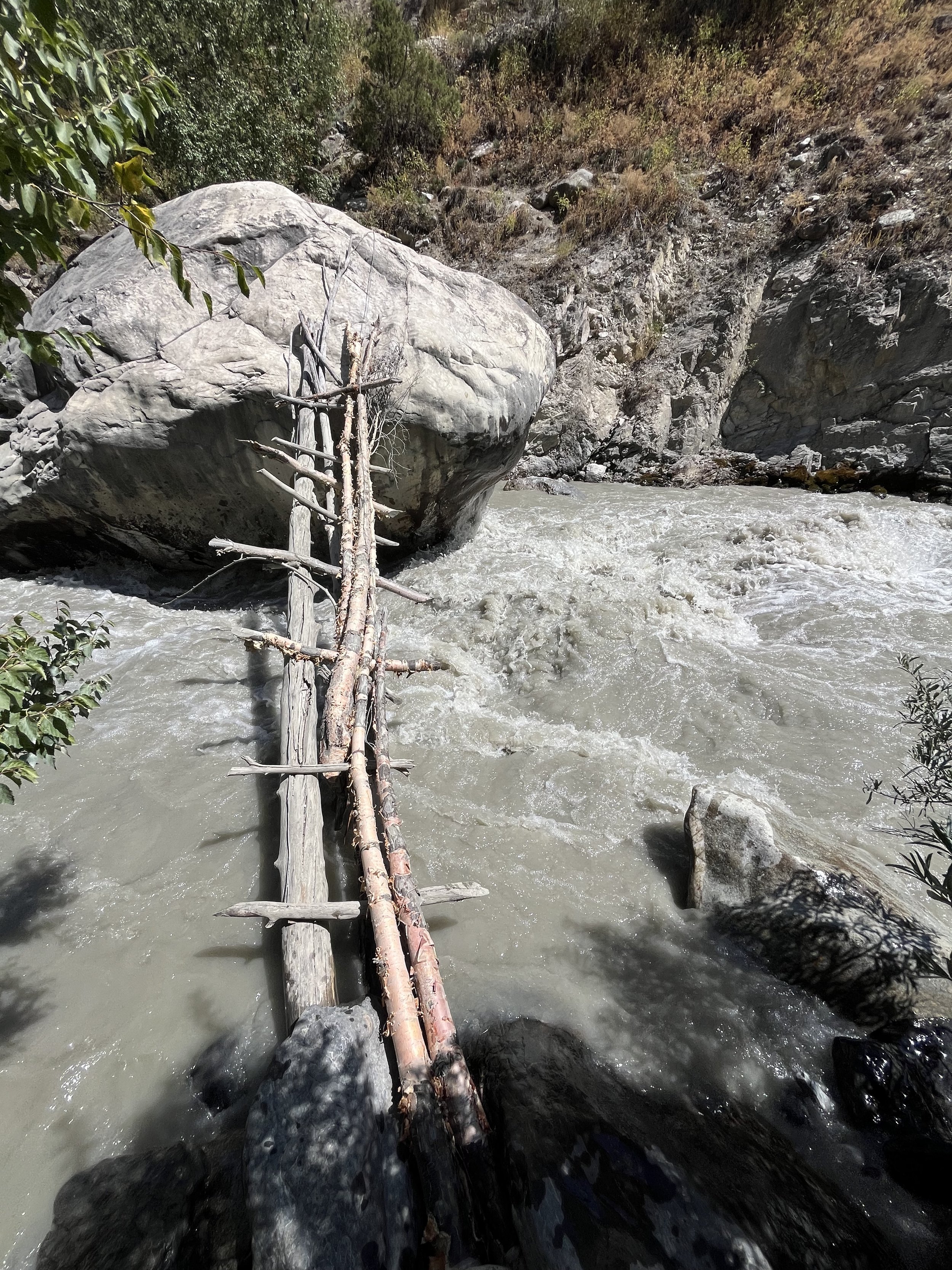
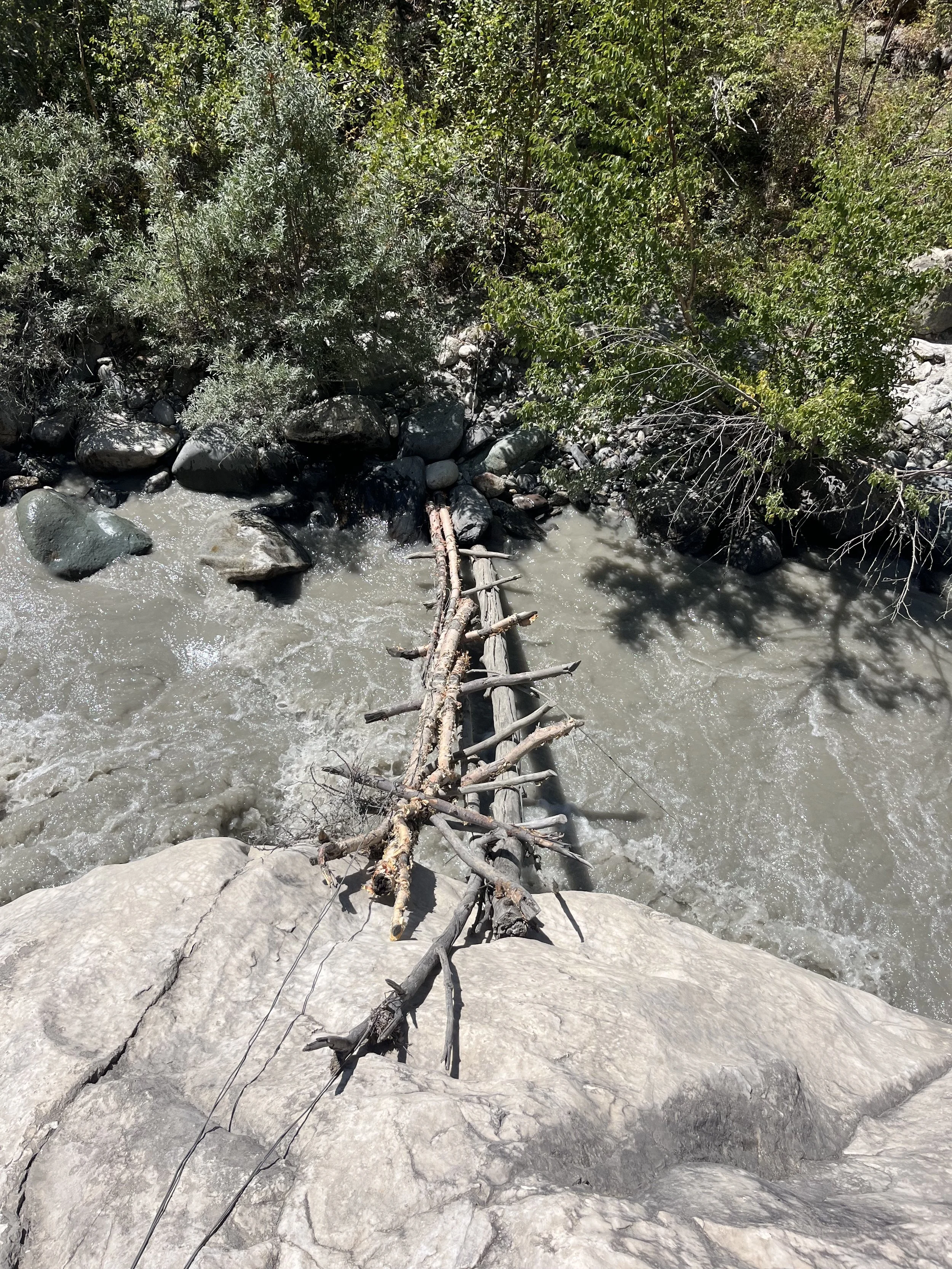
In Arzing was advised by locals that a crossing of Nusay is possible, but dangerous at both the livestock crossing and the upper ladder/boulder crossing.
This is the ladder crossing, made from birch poles that are in various stages of decay (photos below). On my return trip the Nusay livestock crossing was impossible (8:14 in video), so I used this ladder bridge crossing and it was quite unsafe. The ladder flexes as you crawl across, and the right bank access to the crossing is an unpleasant down-scramble. It’s not hiking, but a sort of climbing instead. Downriver from this ladder bridge is a narrow cascade. If you fall in you probably won’t be able to get out of the river (i.e., you die).
At 830am I crossed the Nusay River. You can see the water levels at in my video (0:54). It is worse than the video shows. The water level was consistently crotch high, and briefly waste high. At its deepest I was bending my knees and leaning upriver. On the far side towards the right bank I was briefly pushed down river a couple meters, but I didn’t lose control thanks to some luck with good footholds. There was a strong current, obviously. Downstream has “exits” if you slip and get washed downriver, but you’ll get fully soaked and maybe lose your pack. About 25-30 meters downstream is a wider area to cross where it may be shallower. But that was my emergency exit if I got carried downstream. But still, there is a good chance of dying here. That’s why the locals say what for the last week or September or preferably the first week of October.
Building a footbridge here would be a simple chore with the narrow span and height of the river banks. Overall summary: Don’t do this river crossing. I certainly won’t ever do it again unless I’m here in late September to early October when the water levels drop significantly.
Note: I do all my river crossings here in a pair of trail runners, but I hike in a separate pair of boots.
As I dried out on the other side of the Nusay River I was greeted by a herd of a dozen bulls. Then many more cattle later. They are either friendly or slightly skittish, but not mean or aggressive. These are the cattle belonging to the people in Arzing and villages below that spend the grazing season by themselves without a shepherd. Even when the water drops at the end of the season the cattle still need to be pulled across with a rope. They clearly have a very good sense of self preservation. They are also scared of the Batrud River and will not cross it, so you won’t see any livestock after that point – a rarity in Tajikistan.
Between the Nusay River and the Batrud River you need to collect water from a mountain stream at about the halfway point (it’s obvious on the map). The water is nice and clear. The higher you go for the water, the less the cattle will have walked in it. This is an important chore as the next water source is not until the Rovak stream. Note: the locals tell me that you can drink any river water along this route, by which they mean the glacier silt water that is grey or a grey-brown color. I don’t like the taste of the silt but I find the water just fine after letting it settle in a bottle for a few hours at camp.
At 11:25am I had finished the Batrud River crossing (1:23 in the video). The first channel was knee high with a brief mid-thigh strong current. There was an easy exit downstream if I had slipped and went downriver. The second channel was smaller and easier. It maxed out at knee high. The Batrud River looks like it meanders quite a bit. So when you are here there may be more or less than two main channels, and they may be in a new location. For my knee/thigh references, note that I’m 5’8” or 172cm tall.
On my return trip at 10:45am I crossed the Batrud and the current was above my knee but not so strong a current or steep as earlier. No worries again.
It is not possible to build a footbridge here at Batrud, as the river is too wide and it meanders far too much.
After crossing, make sure to look up the Batrud Valley (1:30 in video). It is in my opinion the first sight worthy of a national park. Hiking up this valley to the glaciers would make for an interesting trip. Unfortunately I was limited by time and food supplies. A higher route through the Batrud-Skogach Pass is a possibility, depending on how easy or hard the trip up the river is.
The video below is zoomed in using a wide angle lens on my phone. Again and again I saw amazing sights with my eyes that I could not get in good quality as I did not have a telephoto lens. So bring one if you have one.
The trail between the Batrud River and the Skogach River is up on the mountainside in the grass. It alternates between clear and vague. Some spots have some low rose thorn bushes creeping over the trail or a few rocks that have fallen onto the path. There is obviously no trail maintenance being done here, and the cattle don’t venture this far. You are now on the old trail to the upper villages that were abandoned 120-130 years ago. From what I can tell the trail’s main users these days are bears. Every single part of this route is home to bears.
I reached the Skogach River crossing at 2pm (14:00) on a warm almost hot day (no video for that). The river was knee high to mid-thigh. But it was steeper and faster than the Batrud River, and faster than the Nusay River. Another problem was loose rolling rocks and bad footing. I eventually stumbled and fell face down on all fours and crawled the last 10% of the crossing after falling and going downstream about five or ten meters. The end result was a full soaking of my clothes and some deep bloody scrapes on my legs.
If I had not stumbled I would likely have congratulated myself on my river crossing skills and said it wasn’t so bad. And maybe yes I would have been successfully 80-90% of the time. There is another anecdote for the crossing here by HarryKuril who crossed the Skogach River on August 4th of the same year at 12:30pm and described it Britishly as “not trivial.”
A better crossing strategy coming from the west would have been to sleep by the Nusay River, not Arzing, and then gone as fast as possible and done all three crossings as early as possible so that I wasn’t crossing Skogach at 2pm. Again, late September to early October and this crossing will be simple and safe.
On the way back I crossed Skogach at 8:10am with much less difficulty than previously. The river was over my knee and with a swift current (7:50 to 8:03 in video). I could have gone downstream for a wider and less steep crossing, but I wanted to cross where the trail starts on the mountain slope. With a higher vantage point on my return trip I could see that cliffs on the left bank block a higher crossing of Skogach.
Note that the Skogach River looks like it changes course a lot. Any exact location advice for a crossing is useless. As for future bridge building, the river bed is too wide and the river channels meander too much. Building a bridge here would mean losing it every single year, or arriving to find a bridge over a dry channel and a new channel before or after that.
By 5:20pm (17:20) my tent was set up at the abandoned Abdulhasan homestead. A better camp would be at the abandoned village of Rivak as there is better ground, a better view, and it’s closer to fresh clear water. However, I wanted to get a look at what the Minadu River looks like at the end of the day. And it was completely impossible in the later part of the day (no video).
On August 22nd at 5:30am Minadu’s water level was down noticeably (2:46 in video). I crossed the Minadu River at 640am. The current was swift and knee high, with splashing above that. There was good footing and I was able to keep my balance. On my return trip I crossed at 550am. Briefly the current was knee high and swift. It was about the same as my earlier experience.
The 2021 French hikers had a problem here at Minadu and spent a lot of time searching for a crossing. They eventually used their climbing ropes to get across.
The Minadu River at the crossing area is not steep. There is a good exit below and I’m very confident that I could get out there without losing my backpack if I slipped and went downriver. The ford location on the Minadu is in an exact location, just as with the Nusay. The Open Street Map trail route now reflects this.
The narrow Minadu gorge above the crossing has huge boulders in the river and trees growing along the banks. Bridge building is a possibility here with short birch logs. Likely a two-section bridge, not one span.
In the Minadeh area the trail is occasionally very vague in the old farm fields. But it’s not possible to get lost here, and you can choose your own route in some places. Eventually the trail becomes clear again after leaving Minadeh.
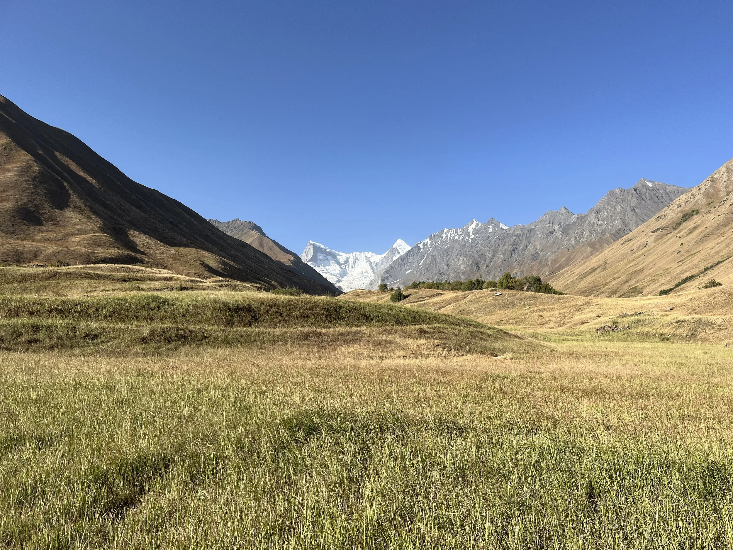
Photo below: the view of the Minadu Glacier from the abandoned fields in Minadeh. It is much more spectacular in person (in person the glacier is much closer), versus this view with a wide angle lens. Again, bring a telephoto lens.
The Suroysha River is the safest and easiest river to cross. The current was below knee height and a wide crossing spread the water out over an easy and almost flat area (no video). It is also very safe below. There was no risk at 830am. I noted a piece of old bridge platform washed up on shore from above. Later I was told that indeed there was an old bridge upriver that was destroyed.
There is low enough silt levels in the Suroysha River in the morning to be filterable.
On the return trip I crossed the Suroysha River at 230pm (14:30) on a cooler overcast day. It was an easy crossing with the current just below knee height. However the river water was now silty, unlike the previous morning crossing.
Walking up to the old village of Dashti Suroysha there is a trail on and off that gets clear once you are above and alongside the old irrigation ditch.
By 11:55am I was jumping across a small creek (4:26 in the video), the higher of the two tributary streams on the right bank of the Suroysha River. Both of these streams had clear water with springs as their source.
Before leaving Dashti Suroysha you need to make a decision on which approach to take to Suroysha–Siyoh Lozar Pass: The first gorge (Chapdarai Avval) that is a direct approach, or the second upper gorge (Chapdarai Duyum) that adds a second pass (Chapdarai Duyum Pass) to the trip over the ridge. Both of these routes are open terrain with no visible trail. The first lower gorge (Chapdarai Avval) is quicker and you will have access to water for most of the way uphill. But you also have to push your way through some tall vegetation and willow shrubs, though nothing prickly or scratchy. And then the upper part of the Chapdarai Avval gorge is rocky and slow with a quick trip on an avalanche snow bridge. The second upper gorge (Chapdarai Duyum) adds some extra time and elevation with the extra pass/saddle, but it is very easy terrain. The Chapdarai Duyum gorge is dry after the springs just above 3300 meters, but these springs also make for a great camping spot if you are getting close to camping time. You also get to see the upper Suroysha gorge on this route. The first lower gorge (Chapdarai Avval) would make for miserable camping in the narrow and rocky gorge.
It was another hot day and very warm even at 3300 meters. At 3450 meters it was still warm, and nice only when the wind was blowing.
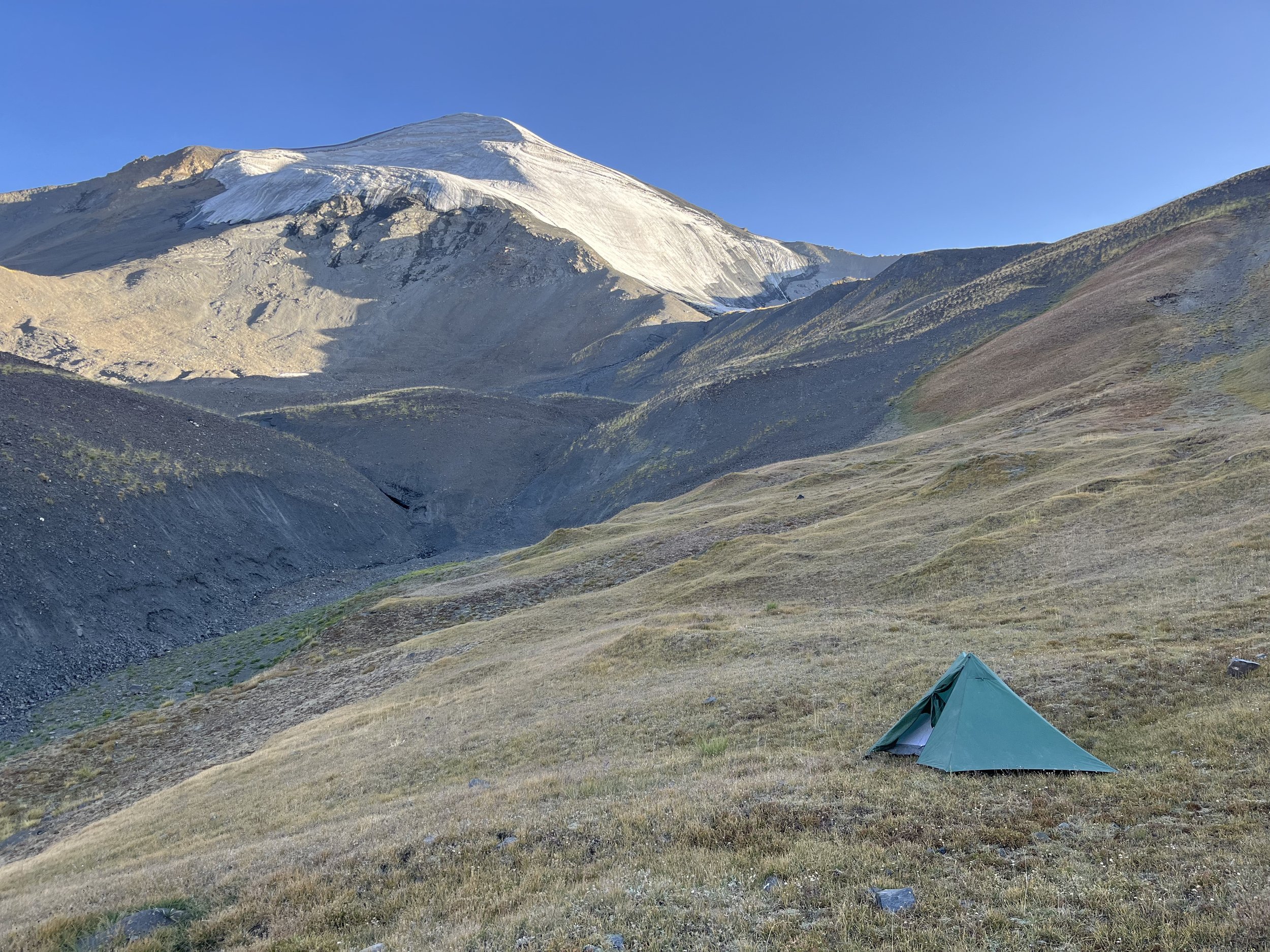
At 515pm (17:15) I was in Chapdarai Duyum Pass after a trip up Chapdarai Duyum gorge (4:42 in video). It was safe and easy but a good workout. There were old ibex tracks dried into the mud right before the pass. By 540pm (17:40) my tent was set up at the bottom of the pass at about 4000 meters near some small springs. I stopped early as I wasn’t sure I would find any good camping spots after this (I was correct).
Photo below: camping on the east side of Chapdarai Duyum Pass.
On August 23rd I was hiking by 5:50am. There was just a little frost at the 4000 meter camp. By 6:55am I was in the Suroysha-Siyoh Lozar Pass (4:55 in video). It is a very easy and totally safe pass. Going down saw I saw a mother and baby ibex, then a herd of seven. I also saw Himalayan snowcocks (locally called Kabki Hilol). As usual, there are signs of bear activity everywhere.
After a slow and rocky but safe descent in the lowest section of the gorge (starting from about 3400 meters) I arrived at the 3195 meters spring (photo below) – the only place in this gorge where I found clear water.
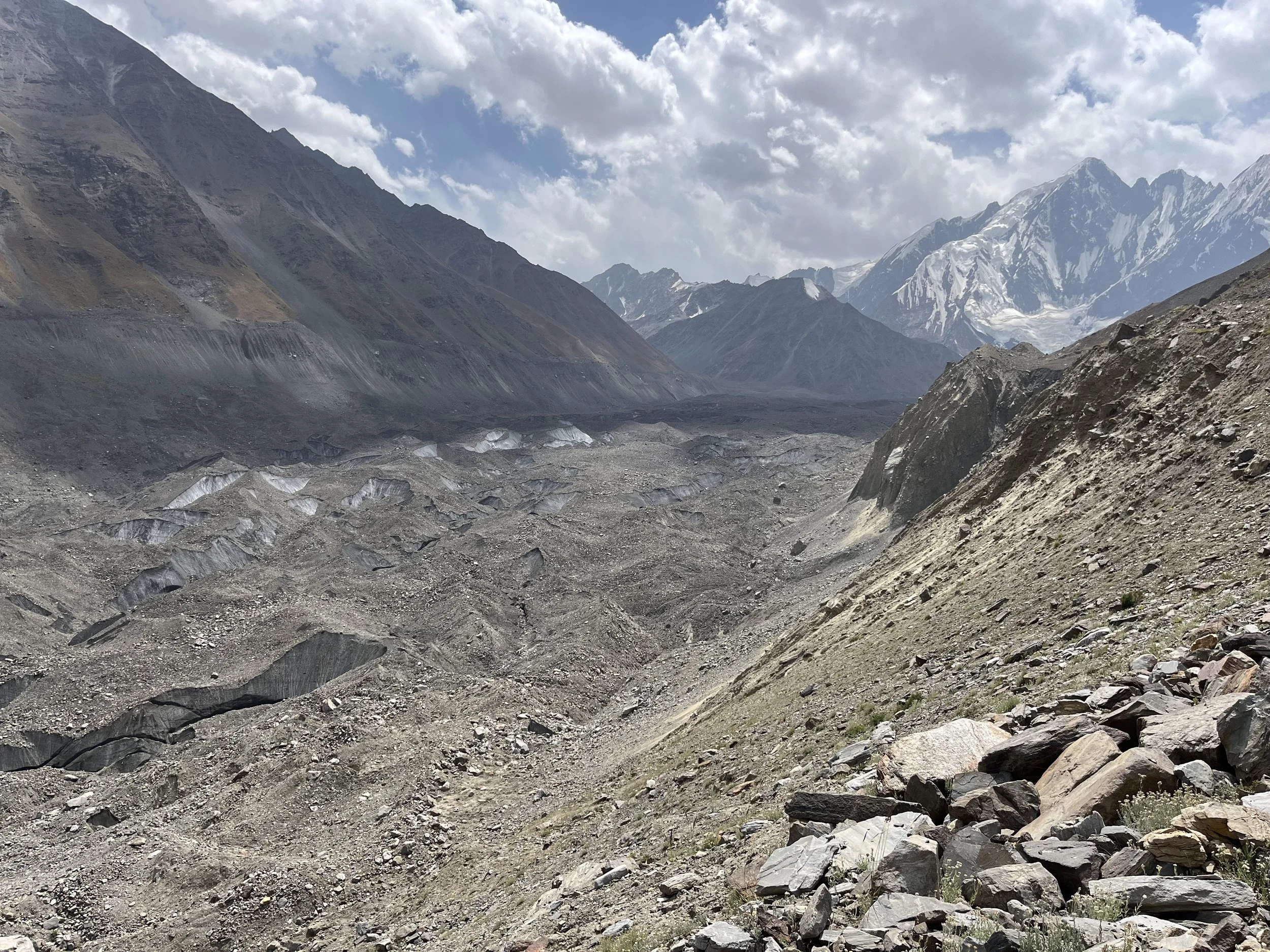
My route on the left bank was eventually either blocked below (multiple times) or I was met by a too-steep eroded slope on the high route in multiple places (high, medium, low). What is on Open Street Map data is the least-worst route to the glacier. Some is quite easy and flat on a wide grassy bench, and then sometimes you are on steep grassy slopes that slows you down.
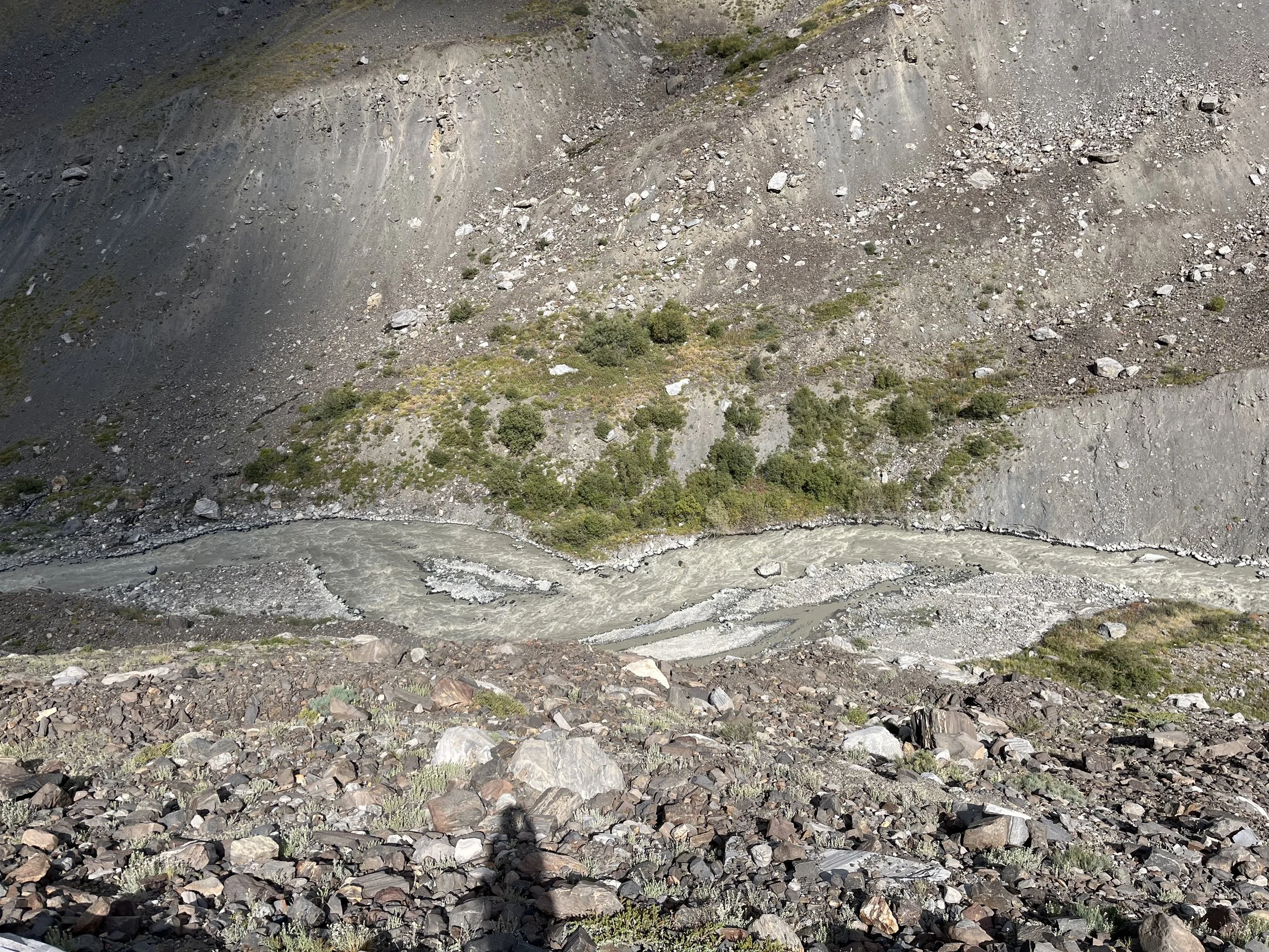
I had a good view of the Vanjob River starting at 9am and it was 100% impossible to cross anywhere at any point up until the glacier (5:11 in video). I’m not even sure it would be crossable in this gorge at any time of the year. However, if the river is crossable in October, it will be at this point in the gorge (photo below) at these coordinates: 38.72218 71.67678
Maybe when the Siyoh Lozar Glacier was bigger a person could just step right onto the glacier, but now you are greeted by a steep dangerous drop down an eroded moraine slope.
I looked around for quite a while and I found the route the ibexes were taking. It was a steep short chute, but dangerous enough to make me think that the possibility that I would end up at the bottom of this chute unconscious with broken bones was not low - especially with my heavy and large backpack. And I was hiking solo in an area where it would take the Tajik search and rescue team as long as a week to reach me even if I was able to send an emergency satellite signal (no helicopter long-line rescues here).
These are the coordinates for the start/top of the chute that the ibex were using: 38.71126 71.66977
I think that if I was coming the opposite direct with a lightweight set-up, I would be comfortable going up this gravel chute with crampons and an ice axe. And I think local shepherds could do this chute. I’ve seen them doing crazier things. However, with the glacier receding and the ice underneath the gravel and slopes also melting, it is possible that the shape of this slope may change for the worse. As for cutting in an angled trail, it would take several days of hard work and some heavy hand tools (picks and mattocks).
So this is where my trip ended. I turned back and returned to Arzing. But what if I had gotten down this chute? Everything after this point is speculation. Obviously I’m not looking to cross the river, but right at the toe of the glacier it looked like an easy safe crossing on the rock and gravel layer that covered the glacier (5:22 in video), and I could also see a route that angled up the glacier towards my destination. But this glacier changes every year and these routes may not be as easy or clear.
In 2021 two French hikers made it down this moraine obstacle. But one of the hikers almost fell (to their death or serious injury) while doing it. Note that this was 4 years before my attempt, and the receding glacier also involves buried dead ice you do not see melting in the area next to the glacier - changing the shape and steepness of the surrounding area. So the moraine may have been easier when they were there - or it may have been the same.
Photo below: the toe of the Siyoh Lozar Glacier. The steep drop that blocks the route is not visible in this photo.
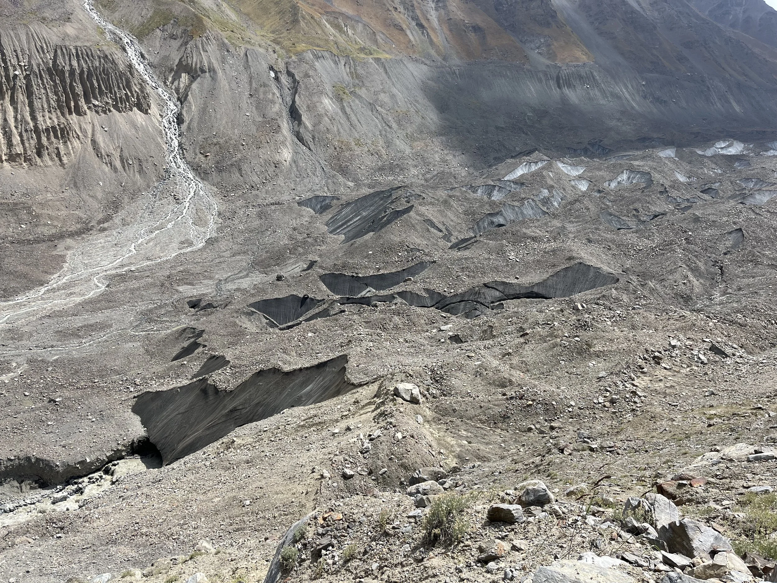
Photo below: Siyoh Lozar Glacier. The center of the photo is the route I could see (from higher above) that angled up the glacier. The 2021 French hikers were able to slowly make their way across the glacier (they reported that the gravel/sand on top of the ice was very soft and slow at the beginning). The destination would be the first gorge/valley on the left. Once you make this turn - if you can make this turn - you need to get up a gorge and by one lower glacier before getting on the glacier that leads to Shirgovad Pass. There is no up-to-date satellite imagery that shows the state of this small lower glacier. It may be impassable - even for climbers, despite the successful 2021 trip by the French hikers. All satellite imagery - which is out of date - shows a very ugly intersection of a moving glacier icefall, a cliff, and a river at these coordinates: 38.66414 71.66987.
Update: At the end of 2025 Google Maps added new aerial imagery for this “ugly intersection,“ it looks less bad now.
However, the French hikers in 2021 reported that it was easy after the Siyoh Lozar glacier and through Shirgovad Pass (but they are also climbers, so their “easy“ may not be your “easy“).
I strongly feel that an approach from the Vanj Valley side is the best approach. This way you will, starting from the village of Shirgovad, meet these potential obstacles earlier in your trek than did I on the approach from Sangvor National Park. However, you should be experienced with glacier travel to attempt this. The good news is that since you have to wait until late September when river levels are lower, the glacier on the north side of the Shirgovad Pass will be at its maximum extent of snow melt - leaving the glacier crevasses visible. But perhaps not all of the crevasses. And fresh snow which can occur on any day of the year may cover these crevasses. So again - you should be experienced with glacier travel before exploring here.
I have done as much research as I could, but I was not able to visit the village of Shirgovad or the shepherd camp above. I’m sure there is someone here who knows the pass well (but maybe only the saddle and not the glaciers below).
For now all I can do, besides noting the French hikers reported the top glacier and pass as being easy, is to refer to a video (below) uploaded by a guy from Shirgovad. I think it is sometime in July based on how much snow there is. Annotations below the video.
Video annotations
Ignore everything before 2:15. That’s a view to a glacier that you won’t be going on. After 2:15 his vantage point is facing west on the ridge near the West Shirgovad Pass (for climbers only). But his video then pans down the Safed Lozar Glacier that is on the north side of Shirgovad Pass.
At 3:10 he is facing the opposite direction and you can see Shirgovad Pass on the lower right (the low point on the ridge). At about 5:05 I think he is walking in the saddle that is the pass. But I’m not 100% sure. Maybe 90%. He then goes down the pass to the glacier after about 6:45, saying “bismillah“ for protection before heading down.
Starting at 7:11 you can see his steel-tipped shepherd stick - a great tool for traveling over ice and across steep chutes (you can cut in steps into ice and hard gravel/dirt with this tool). At 7:45 you can see a crevasse that will absolutely kill you if you fall in.
at 11:30 he is back up in the pass. Starting at about 13:15 he pans his camera down the glacier to the north (the route you would need to take). At 13:43 he says that at the bottom there is a left hand turn is a very difficult scenic dead-end, and that you should go to the right (down the Siyoh Lozar Glacier). Unfortunately you can’t see the lower middle glacier and the obstacles there. He doesn’t give out any more information on the route aside from this brief comment.
At 14:40 the camera is pointing back down to the Vanj Valley, showing you how close it is.
Note that he talks about a Siyoh Lozar Glacier, but that’s not the large one that I went to. Instead it’s a smaller glacier of the same name in the Vanj Valley side that is to the southwest of Shirgovad Pass (you won’t be on or near this glacier).
I don’t think the guy taking the video is the same person who runs the (inactive) Youtube channel. But if you need a guide to get up to the pass (not sure what he knows north of the pass), this guy is probably the one you want. You can show his face to someone in Shirgovad to track him down (you can see him in this video starting at 7:37).
Getting from Shirgovad village to the livestock corrals just above 3500 meters seems like easy work - after this the trails fade.
Satellite Imagery
For planning a trip through Shirgovad Pass, you can check out satellite imagery on maps by Google, ESRI, Mapbox, BING, Apple, etc…, but you will notice that as of late 2025 some of it is the exact same duplicate imagery, and some is out of season and you are just staring at deep snow (and all of it is very out of date as of 2025). The easiest way to see current satellite imagery is unfortunately low resolution, but still helpful. This tool is the Copernicus Browser. It takes a while to figure out, but once you do you can see, for example, some clear images of a snow free glacier at Shirgovad Pass on 14 September 2025. But then if you go forward in time you see a storm that leaves a light snow covering on the glacier for the rest of the season. You can check out the archive of previous years back to 2016.
Soviet Era Climbing Reports
I’ve gone through all of them. Shirgovad Pass is not mentioned often, as this region was used by the highest end of Soviet climbers who were headed for some very challenging ice falls, not easy glaciers. A very short summary description in Russian of the pass from the mid-1970s is very likely no longer relevant with changing glaciers.
Notes on names
Many names on the Soviet era maps (i.e., the GenShtab map, or “Soviet Military Maps“) are incorrect. This is the case with not just the Nusay River as noted above, but with other locations relevant to this route. All names on Open Street Map along this route are now corrected. Notable is that what is incorrectly shown on the old map as the Bokhud River and the Zardi Birauso or Dehbarob River is actually one single river: The Vanjob River. Yes, this is the same as the main river in the Vanj Valley. But this is normal in Tajikistan to see duplicate names. In Arzing, Rogha and other villages they will refer to the river as Vanjob, not Bokhud.
Note that there is another smaller village also named Shirgovad in the Darvoz District (down the Panj River from Qalai Khumb).
A local in Arzing was referring to something in the gorge above Dashti Suroysha as “Kuraysh,“ but I wasn’t able to get it clarified (name of the upper gorge? name of a grazing area? a secondary smaller abandoned settlement? I don’t know…)
The historical name Vakhyo for the region of the upper Khingov River and its tributaries is still known by locals.
Random notes
I found a tick crawling on me at the Minadu camp (it didn’t have a chance to bite me). This is then first time ever in Tajikistan I’ve seen a tick, and I’ve been nearly everywhere over more than 15 years in this country. I credit this to the lack of livestock grazing in this area. Elsewhere the grass and brush is grazed down low and ticks need high grass or brush to jump onto you.
I saw very old horse manure as far as Rovak. But very little and old. I asked in the village of Arzing if horses graze here, but a man told me this was from his horse trip the previous year, not from any regular horse grazing. A good horse can apparently go as far as Rovak.
The tiny villages along the Vanjob River (Rovak, Minadeh, Dashti Suroysha, Pshatgo, etc.) grew barley in irrigated fields and herded livestock, but they were abandoned 120-130 years ago after an extremely bad winter. Then they were summer-only places after this point. These villages were later fully abandoned after the communists deported people from all the lower villages of the district (they were allowed to return in the late Soviet period and rebuild, but nobody returned as far up as Vanjob).
Bear, bears, bears. Bears are everywhere here. In Tajikistan they are shy, but still not always safe to be around.
Maps while on trail
Read this warning and guide about map apps for use in Tajikistan. Bridges collapse, trails erode away, things change. Tajikistan’s mountains can be super harsh. Use my GPS track at your own risk: GPX file download.
How long will it take?
I was carrying a very heavy bag. It was a traditional hiking set up; not light weight, and I had enough extra food to be able to turn back and return the way I came. Also, I was exploring and went the wrong way more than a few times. Plus there were the times I had to stop early in the day to camp by a river and wait for a morning crossing. And it was the end of my 5th month of hiking. So I was slow. Someone in good shape who is going lightweight or ultralight should be able to go much faster than I did (2.5 days from Arzing to Siyoh Lozar Glacier).