
Nurota Mountains Hike
Nurota Mountains Petroglyphs, Ruins and Gorges Hike
The Nurota Mountains Petroglyphs, Ruins and Gorges Hike is an approximately 65km (40 mile) hike in Uzbekistan (Nurata or Nurata spellings are also used). Despite being a mountain hike, the elevation is not high compared to mountain treks in the rest of Central Asia, with the low point being about 600 meters and a high point of 1650 meters. Due to the high summer temperatures, this is a route suited only for the spring and fall seasons. This is an unofficial route, and it follows mainly shepherd trails and some open terrain. The trek goes between the villages of Sentob and Katta Ej.


The Basic Info
Length: about 65km (40 miles).
Terrain: mountain slopes, gorges, riparian, farmland, steppes.
The route: shepherd trails, farmland track roads, old dirt roads, brief sections of open terrain, and village walks.
GPS track and waypoint: Download GPX file. Note that on the GPS track the brief 3km section between waypoints labelled “Point #1“ and “Point #2“ was not hiked by me; rather it is my suggestion (to avoid my longer detour to the north that is not in this GPS file). In the far western section of this route you can choose your own route in the Tashbulak gorge. It’s easy open terrain with many route options.
Obstacles: None. Any stream big enough to be a problem has a bridge crossing. Snow won’t be remaining on any of the mountain sections after early spring. There are no technical slot canyons or hard scrambling over ridges. There are a couple of wooden fences to climb over, and a couple of barbwire fences to get through.
Wild animals: Rare, sadly. No mosquitos or biting insects (in nature; fleas may be present in shepherd huts and, rarely, bed bugs in houses). Mountain gorges are full of songbirds in spring. You will see plenty of domestic livestock: sheep, goats and cattle. If you’re lucky you may see Severtzov’s Argali (wild sheep). I saw two wild sheep in the eastern section (high above me in the ridge).
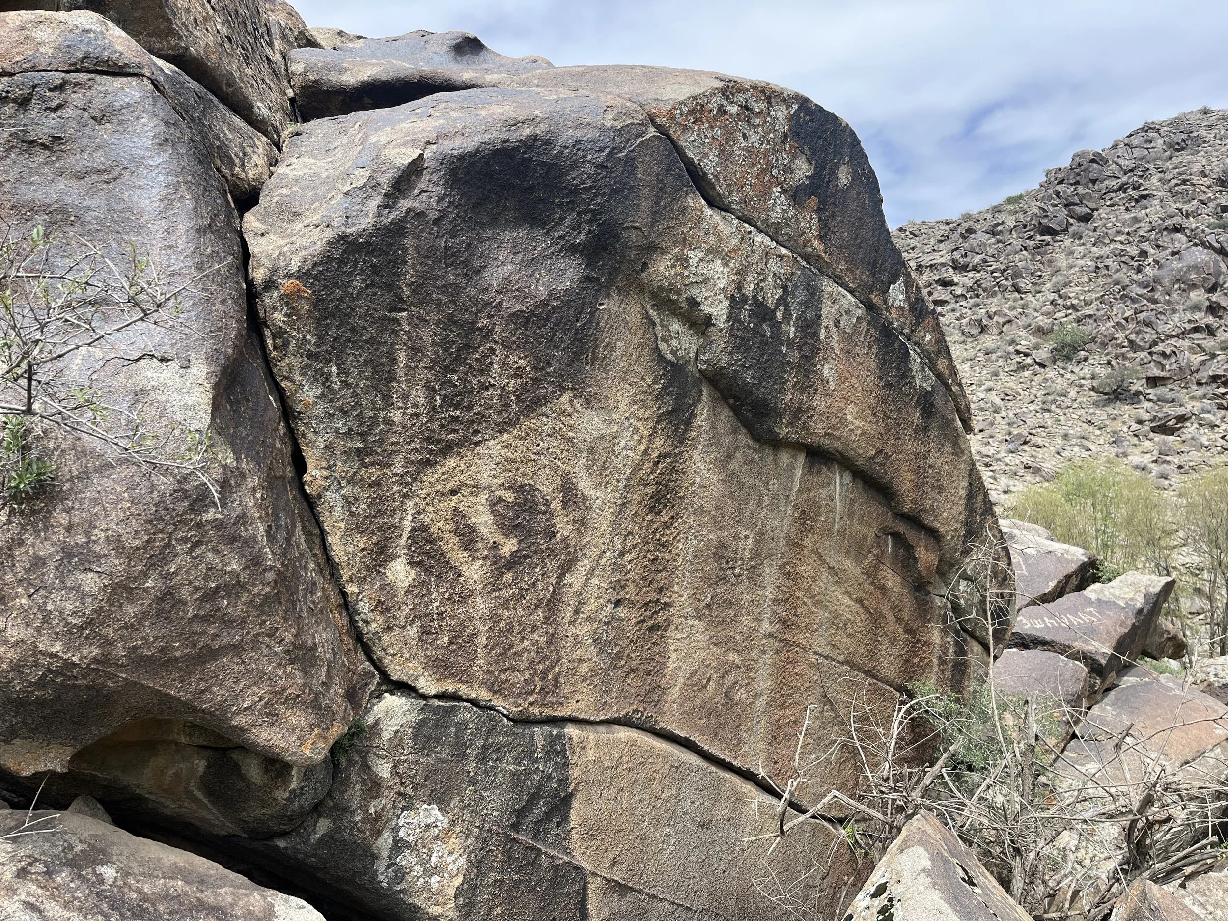
Attractions: For me, it was the many petroglyphs, ruins and the strange geological formations. The gorges are also nice riparian zone with interesting trees and vegetation.
Can this hike be extended?
I hiked between Sentob and the village of Porasht (Eski Forish) to the east. But I don’t recommend it. The terrain is very steep and loose, there is lots of road walking, and the scenery is not good enough to justify hiking the area. It’s best to drive to do short hikes to see attractions like the ancient Archa Tree in Mojarm (Majrum). And you also need to consider that the nature preserve to the east blocks you from exploring the higher areas.
I also hiked from this route to the next mountain ridge to the south (Chuya, Langar and skirting the Oqtov nature preserve) and then to the town of Nurota. I do not recommend that hike (too much road walking, not enough natural beauty, some suspicious locals doing their own independent interrogations of me despite not being law enforcement, etc.).
I reached this region by walking and hiking from Samarkand to Aydarkul Lake, and then west to the Nurota Mountains (in about a week of very fast walking). I definitely cannot recommend this long walk. The farmland was uninteresting, the foothills and mountains were not as good as the Nurota region, and finding water was a challenge. However the people were quite nice and friendly along with way, with only one interrogation by a police officer (who quickly photographed me and my passport and then let me continue). Part of this route by the lake is now completely prohibited as a nuclear power plant is being built there.
The Difficulties
To be clear, you must have a tent. There are guesthouses at the beginning and end of this route, but you cannot hike from guesthouse to guesthouse continuously.
You need to manage water supplies. In some areas, there is plenty of water (springs in the mountains, food stores in villages, water pipes near farms), but in some areas you need to carry some water.
Food supplies are limited in selection. Small villages stores don’t have much to offer. Bring all the food you need.
In the rural areas nobody speaks English, and only a few older men can speak Russian well.
Minor annoyances include barking shepherd dogs (but far less aggressive than those in Tajikistan and Kyrgyzstan), unclear guesthouse prices and aggressive haggling.
As for local people, those at the very beginning and the end of the trek are accustomed to foreign tourists, but up high and on the southern sections they never see tourists. People were friendly and invited me in for tea and food. I did have two annoying encounters. One shepherd asked for my power bank as a gift. I really, really need my power bank so I declined. And in one of the villages on the southwestern section I was invited in by a local who then photographed my passport and sent it to the authorities (who no doubt could not care less). He then begged me to buy him a bottle of vodka.
Off route is where I met less friendly people. When I exited this route to the town of Jo’sh (where you will not go) I was asked for “documents” by a farmer in one of the upper villages, upon entering Jo’sh I was grabbed by the arm by the local street drunk, then I was stopped by law enforcement who aggressively asked me questions in Uzbek until they were diverted by a mentally ill person attacking passing cars. The villages of Katta Ej and Sentob are far more friendly. The locals and visitors to the Archa Ota shrine were very friendly and kind.
More reasons you may not like this route
Expensive guesthouses. This is not Kyrgyzstan or Tajikistan. Expect to pay double or more in Uzbekistan what you pay for the equivalent quality in mountain guesthouses and homestays in Kyrgyzstan and Tajikistan.
The guesthouses in the mountains here are targeted at tour company groups, not individual solo travelers (who certain guesthouses seem to see as an inconvenience). Some are asking $50-75 per night for solo travelers. Cheaper rates can be had at less luxurious guesthouses, but there is sometimes aggressive haggling to be performed first. Nuratau Travel, a community-based tourism organization for the Nurata/Nurota mountains, has standardized homestay prices in this region at 30-35 Euros per person (as of 2025), including dinner and breakfast (at participating homestays in their network). I found them to be asking for $35 per person, with dinner and breakfast included.
Best season to hike
Spring or fall? Fall is very dry, spring is more likely to have short spells of rain. You need to be more careful with water sources in the dry fall. You won’t get nice green grass and flowers in the fall. But you get consistently dry weather and dry trails in the fall. And in fall most of the shepherds and flocks have left the mountains, leaving you with more peace (and less guardian dogs).
If you are OK with some warm weather hiking, then aim for the last week of September as the earliest possible starting date. First week of October or later for everyone else. In the spring I would try to be off the trail by the last week in May. But note that hot weather can arrive unexpectedly at an earlier date. A mid-May finish would be safer. So, stay off the trail from mid-May until end of September. If you have high tolerance to warm weather or you follow strategy of not hiking during the hottest part of the day, then you can extend the hiking season here.
Winter? Sure, but you will need to adjust my clothing recommendations and take more warm clothing (plus rain gear). And you will need to keep an eye on the mountain tops for snow. As soon as they are white, there is no chance to hike through them unless you know you can spend several days hiking in snow.
Gear Recommendations
A tent is nice for privacy, but you can definitely get by with just a tarp. In the fall dry season you could “cowboy camp” under the stars with maybe just an emergency bivy in case of rain.
The ground is very hard, especially on the steppe and on the ridges. If you find that you need an air mattress for comfort reasons, this is the place to use one. I slept on a thin closed-cell foam mat, and it was doable, but not very comfortable.
As the ground is hard and rocky, don’t bring tent stakes that are too flimsy and weak.
You can definitely skip the hiking boots and use hiking shoes or even trail runners. But again, note the hard ground. A shoe with a decent cushion would be best.
I had an ultralight disposable rain jacket. No need for a good quality rain jacket. I skipped the rain pants in the dry fall season, but had them for the spring hike. I never used the jacket in the fall, aside from as a pillow. But you may get rained on, particularly in the spring.
For clothing, I personally would skip insulating base layers, rain pants and gloves (sun gloves are good enough). I would have a light mid-layer (like a fleece hoody), and skip the insulating jacket (“puffy“).
There are livestock, shepherd dogs, people and wild animals in the mountains. So I use a water filter and then add a chemical treatment as well if I’m suspicious of the water source. Don’t use chemical treatment alone. With the livestock and dogs, cryptosporidium is a concern, and you need to filter for that (if you don’t want to wait for a slow chemical treatment that is required for cryptosporidium). I didn’t filter or treat spring water.
Mobile/cell phone reception is good near villages, roads and on ridge tops. Buy a SIM card upon arrival (if you have an older phone that still take physical cards). E-sim apps are available for your phone. Get the UzMobile SIM card, Beeline mobile won’t work here.
Food and Resupplying
Local village stores are usually just candy and snack stores, bring your own food.
Bring cash. You need cash for everything in the village and on the street. And I mean Uzbek cash. US dollars, Euros and Russian Rubles don’t work in local stores.
Water
I usually would leave a water source with one liter of water. It was always enough. For reference, I am about 70kg/150lbs. This was in late April. In late May you might need to carry more water in the higher temps.
Weather
Need to know exact range of temperatures and chance of rain? You can search weather history and temperature averages for towns and villages in the area at the same elevations as this hike.
Baggage Storage
If you have extra items you want to store while hiking, you can make an arrangement at a guesthouse at either end of the route to store your belongings (in the town of Nurota they may ask for a fee to do this, or they may do it for free if this means that you return to stay another night). For me, this is my cold-weather gear and my boots which I won’t need on this route. Of course, this means that you will need to return to where your extra belongings are stored. Another option is to store your extra gear/belongings at a guesthouse in Samarkand. I would strongly recommend only doing so at a guesthouse that is run by a family that lives on the premises. A hostel run by employees and with an absentee-owner is not a good idea, nor is a hotel that is similarly operated. Look at the reviews on Google Maps or Booking.com to find the details on the owners. Looks for a comment about “the family“ (you may have to read through quite a few reviews). These people will be far more reliable. For Tashkent, I would avoid storing baggage there, as family-run guesthouses are few to none.
Direction of hike
You can start at either end. Westbound or eastbound, both are doable.
Getting to the trailhead
For reaching this area through the town of Nurota, you can get there more easily if you book a room at “Riad Nur & Tours“ guesthouse in Nurota (formerly “Ruslan’s guesthouse“) and message them to ask for a shuttle from your accommodation in Samarkand or Bukhara or from the train station in Navoiy. Full contact info here. Prices may be out of date, but they were “(per car) from Samarkand is $40, from Bukhara is $40, and from the train station in Navoi is $20.“ This hotel can then find you a driver to get to the villages on either end of the hike.
To get to the town of Nurota independently and more cheaply, take a train to Navoiy (Navoi) from Tashkent, Samarkand or Bukhara. Once in the city of Navoiy you need to get to the north side of the city to an area called “Karmana.“ There is a shared car/taxi station here, it is “Navoiy Central Bus Station“ on Google Maps and “Navoiy Bus & Taxi Station“ on any offline map that uses Open Street Map data. You can get to that location by walking across the city as I did (with a break in the city park with pay restrooms and snacks), or you can, since late 2024, use the Yandex Go app to get a taxi (or haggle with the drivers at the train station). At the bus and shared taxi station you need to find the drivers going to the town of Nurota (and you’ll probably have to get past the drivers asking you if you are going to Samarkand, Bukhara or Tashkent). The drivers to Nurota may or may not have a small sign in their windshield advertising the location, and they may or may not be under a sign on the building that advertises the Nurota destination (some renovations and changes may have occurred since I was last here). The cost from here to Nurota in 2019 was 25,000 som ($2). It will likely be higher now. Tell the driver you want to go to the “Chashma“ in Nurota. That will get you dropped off right by the main tourist attraction in Nurota and close to guesthouses.
For accessing this area from the Tashkent direction, you should use the city of Jizzakh (Jizzax) as the access point. You can get a train to Jizzakh from any city in Uzbekistan. If coming from Samarkand or Tashkent you can leave at a leisurely time in the morning and be in Jizzakh by lunchtime. Once in Jizzakh you can use the Yandex Go taxi app here (since the end of 2024) or walk if you want, as the next destination is only 3km away. You need to get to the shared taxi/minibus station that services the Forish District to the west. On Google Maps it is labelled as “ForishBekati” and on any offline map using Open Street Map data it is “Forish District Taxis.“ Once you get in a shared car (25,000 soms); the easiest option is to aim for the district center town of Bogdon (Bog’don) which is still referred to by one of its old names: Forish or Yangikishlak (Yangiqishloq). Once in the town of Bogdon you need to switch to the shared cars/minubuses that service the villages to the west. You’ll probably get dropped off on the main highway just outside the village.