Bazardara High Route
Bazardara High Route
*This is a work in progress* I add information as I find it… Don’t attempt this route. This page is available publicly so that anyone researching travel in this area can make use of what I have found.
The route goes over two high ridges. The names for these ridges/ranges on old Soviet maps is the Northern Alichur range and the Karajilga Range - both totally arbitrary names made-up by Russian cartographers (poached from the name of a village and the name of a small mountain gorge). I’m using the historical name Bazardara - a medieval mining town in the mountains.
The original proposed/planned route started right in the town of Murghob and ended in the village of Bachor, a well known start/end point for treks. However, in 2024 the national park fees were quintupled and aggressive fee collection began in the later parts of that route. I’m not interested in paying high fees to road walk in an area that I do not find interesting (this assessment does not include the hike from Bachor to Bardara, which will probably be worth the $10 per day per person to most people). So the new planned route is shorter and aims to hit some highlights and exit to the town of Alichur. Between Alichur and Bachor is the fee collection area (that I find not interesting enough to be worth the cost).
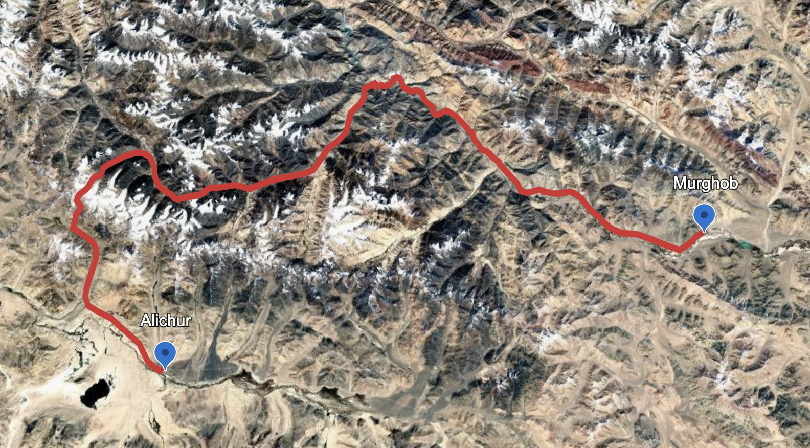
If you want to get a closer look, I’ve drawn a very crude rough line that you can view in Google Earth. Message me if you want the far more detailed GPX of my planned route - complete with river and glacier crossings (that may equal death).
The most important factor to consider is the elevation. This route includes one pass at 5253 meters, and another at 5145 meters. This means that you will likely need to have been in Central Asia for a long time already and at high elevations. This is almost as high as the highest trekking pass in Nepal. Read up on what sort of acclimatization is needed to go that high.
If you are coming from Kyrgyzstan, Sary Mogol Pass at 4300 meters and Traveller’s Pass at 4130 meters are the best choices for acclimatization hikes (this video will sell you on those hikes). If you are coming from Dushanbe, then consider hiking the Fann Mountains near Dushanbe, and once in the Pamirs doing the Jizev-Rozhak hike (4880 meter pass) or the Bachor to Bardara trek (peaking at 4796 meters).
If you are already acclimatized to the mid-4000s, then you could just hire a driver in Murghob to take you straight to the Modiyan shepherd camp (just ask to go to the end of the road in the Modiyan/Madiyan valley). Or walk the road if you feel like it.
Season: Timing your trip for low water levels in the river crossings are vital here, as is the need for minimal snow on the high pass. This means September is the only option. The river levels peak in about mid-August, and start to fall noticeably at the beginning of September. This is a very dry region, and September is a dry month, but it can snow at any time. And weather patterns in this region have been quite wild recently. So it is possible to get snowed on. It is possible to get snowed on between the two high passes and have to exit through a 4600 meter pass (possibly walking in the snow).
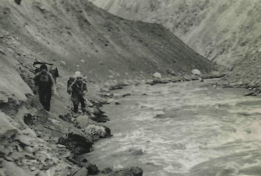
The Rivers: Multiple crossings of the Marghob and Bazardara Rivers, plus countless smaller streams and creeks.
Marghob River: After the Modiyon shepherd camp you will at first follow an easy path: the faded remains of an old bulldozed track that goes down river (west) until almost 3500 meters (elevation). After this it will be very unpredictable. The old GenShtab map (“Soviet Military“ map) shows a route that continues downriver all the way to the confluence with the Western Pshart River, crossing the Marghob twice. This route is fictional. Perhaps in low water this route is possible, but all imagery from boaters show canyons that are impassable or so time consuming to be not worth it. You need a kayak, or a tough packraft, as one couple managed in 2023. But that’s after Jekandikul Lake (where the proposed route turns south). So it may be possible to easily get to the Jekandikul Lake area. But this may be only in the low water season. Or it may be a horseback route that is often in water - not a good plan for a hiker who would soon get hypothermia. This is definitely a “I won’t know until I get there“ situation.
Bazardara Gorge: The Bazardara River is smaller than the Marghob River, but narrower, steeper and faster. I’m not sure if it is possible, even in low water. The route is displayed on the GenShtab map, but again that map shows some fictional routes.
The high unnamed passes: The 5235 meter pass that connects the Bazardara Gorge to the Morjoy Gorge is ice free, but there may be a cornice in the saddle in some years. The west side looks like an easy slope, but the east side is a rocky steep scramble. This is not hiking, it’s scrambling. And a fresh snowfall will block you. If this happens, you will need to exit the area via a mining road through the 4660 meter Bazardara Pass.
This may require crampons and an ice ax. This is a pass that would make a mountain climber yawn, but may be a serious problem or deadly for a hiker, especially considering the height and possibility of snow on any day of the year. I would only recommend showing up to this pass if you have the gear and experience.
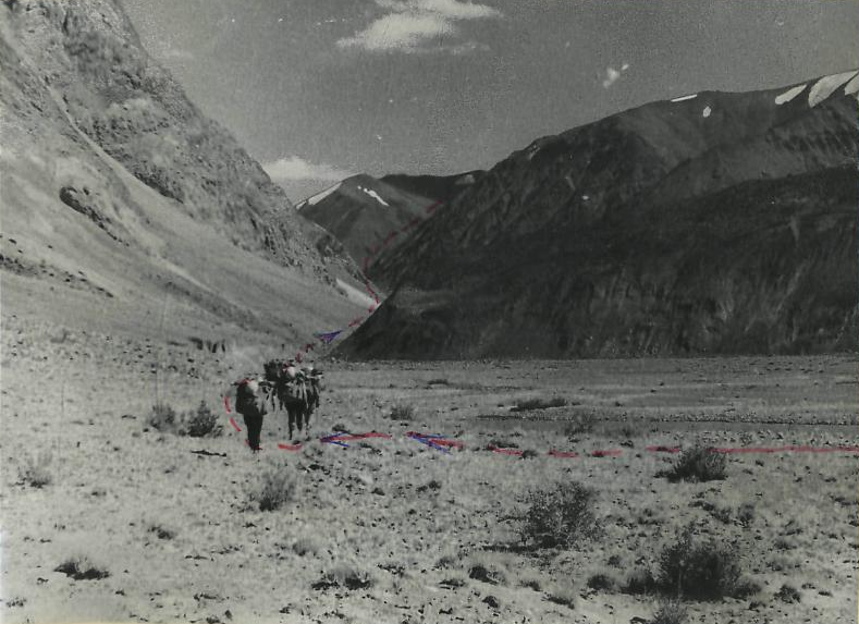
The highlights: I like green riparian zones in dry mountains, so I already know that I will enjoy the riverside walks of the Marghob River and the Bazardara River. The Bazardara archeology site has well preserved foundations that still exist from an old mining town (images at this link). However, many travelers find these sorts of ruins boring (“just piles of rocks“ as one fellow traveler said). Aside from the usual mountain scenery - glaciers, peaks, views from high passes - I’m hoping the three unnamed lakes make for a nice view (not every lake that looks nice on satellite imagery is as nice on the ground).
A “lowlight” will be the Chinese mining roadwalk (about 8km) in the middle of the route. The Chinese silver mine is up a side valley, and you won’t go past it. I see a large tailings pond at the mine site, and I don’t trust mines in my own country, so I won’t be trusting a Chinese mine in Tajikistan. I’ll avoid taking water from the main river, sticking with springs and tributary stream from side gorges.
As for the scenery, I already know the mid-elevations will not be scenic compared to other areas of Central Asia. Check out the trip report of a tourist who drove to the Chinese mine.
Possible alternate routes
Marjanay/Morjoy River: First of all, I need to discuss the name of this river to avoid some confusion. This place name occurs regularly throughout the mountains to the south of Lake Sarez (for both rivers and passes). One incorrect interpretation of the name is “Corral Springs“ (corral existed historically in Central Asia only as an expensive Chinese import jewelry). Only a historical linguist who studies Bartangi would have a chance at finding out what it means. Or perhaps a local person would know. But the problems is that the people who lived nearby died in a massive 1911 landslide (Usoi village) or fled the ensuing flood and lake formation (Sarez village). On old maps the Marjanay River came right down to the now underwater village of Sarez. It was their name, and I don’t know if knowledge has been preserved after they fled to the Bartang Valley. The name Marjanay is also given to two rivers on the opposite side of the ridge by Yashilkul Lake: Big Marjanay and Little Marjanay. It’s not uncommon in Tajikistan for the opposite side of a ridge or pass to have rivers with the same name. Russian map makers solved this by adding north/south or east/west, or by using a different name. You might come across the Kyrgyz variant “Kattamarjanay“ or “Katta-Marjanay“ for the Marjanay River. This means “Big Marjanay,“ which makes it even more confusing - giving the map two Big Marjanays. The Russians solved this by referring to one in Kyrgyz, and the other in Russian “Bolshoy Marjanay.“ The Marjanay River that flows into Sarez Lake was referred to by early pre-flood visitors to Sarez as Marjanay and Marjanay only. Big and Little Marjanay appear on the OSM map on the rivers/streams that flow into Yashilkul. The Marjanay River that flows in Lake Sarez was renamed by the government recently to the completely made-up name “Morjoy“ - a truly confusing choice that means “Snake Place.“
As for traveling down this river, regardless of its name, you have an immediate escape route after coming down from the 5300 meter pass: the easy Marjanay Pass to the south that will take you right to Yashilkul. Note to be confused with the Marjanay (AKA Shadau) pass at the west end of Lake Sarez.
But I plan to go down this river to Lake Sarez, not go through Marjanay Pass (AKA Shaytan Pass). The plan is to do a September low-water trip after the melt season has ended. This is an old shepherd and caravan route, and there are no difficulties except for river crossings. The old caravan route is entirely on the right bank (north east side of the river), from the Suydi River tributary to Lake Sarez. But the GenShtab map tells many lies. This may be one. An old trail can be seen on satellite, but then fades away where floods or moving scree enveloped it. So even in times of low water you may need to get in the river.
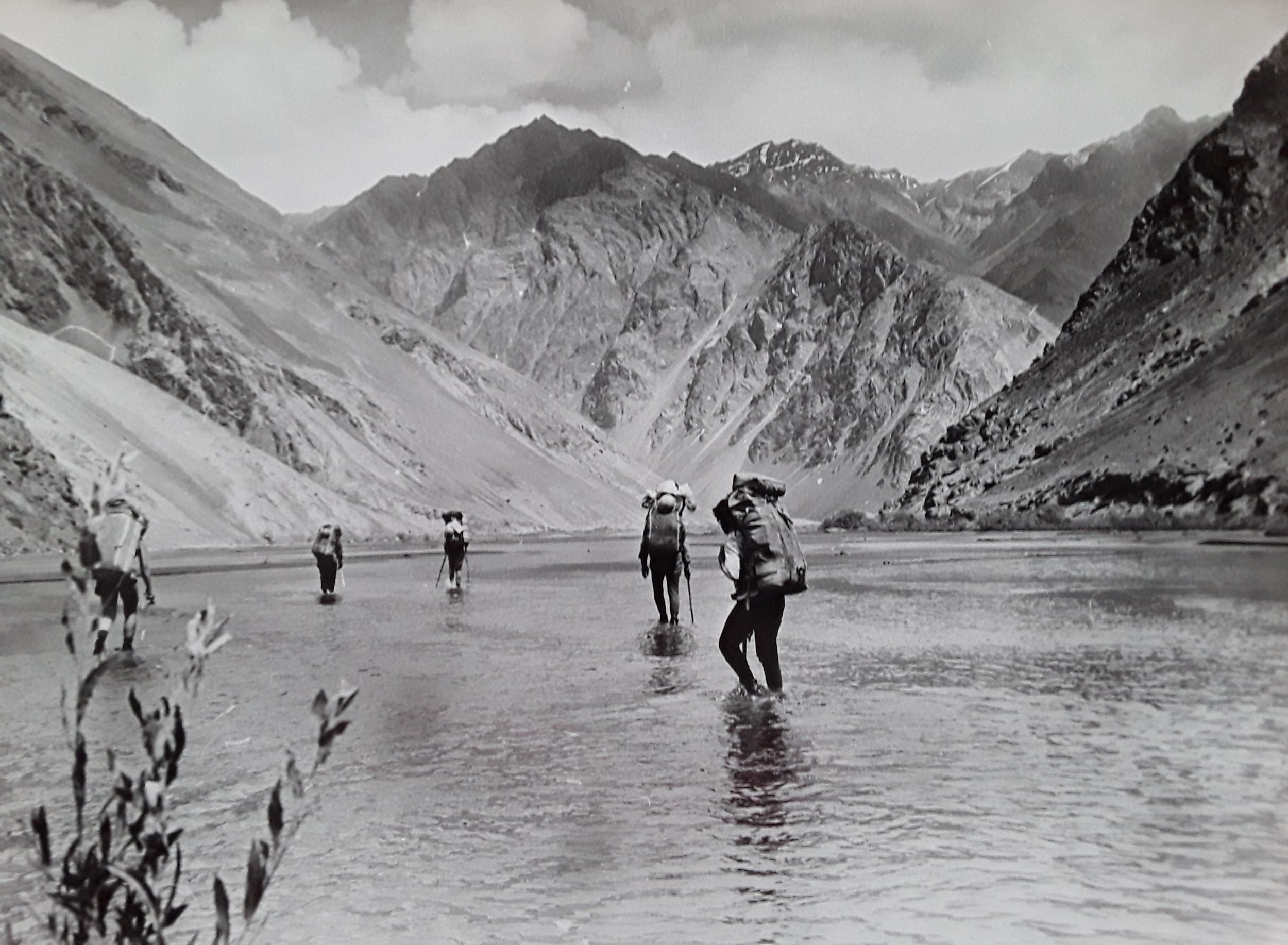
In 1977 the Dunaevsky group from Dushanbe traveled up the Marjonay River from Lake Sarez. They took photos (below) of the difficult sections (for technical purposes, not for scenery). But their route selection may not be relevant, as they traveled during peak meltwater time: August 10th and 11th.


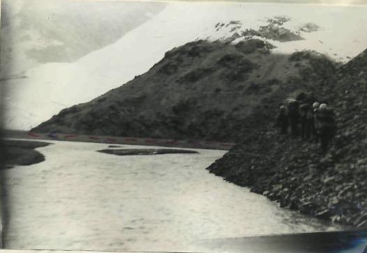

The Dunaevsky group reported that the Marjanay River was difficult to cross, even in the early morning when the water was lower. They report multiple river crossings, including by the use of their gear (ropes, harnesses, etc.), plus going up and around bluffs/cliffs that go down to the water.
Again, none of the Dunaevsky group’s experience may be relevant if you come here when the river levels are lower. What is relevant to the tired and cold hiker is the hot springs. The reported the location as being above the only major tributary river along the left bank. So, perhaps above the Gyols River. The groups provided a blurry photo of a pool that is three meters in diameter, but you can’t see the background to get an idea where it is. And that’s too small to find with thermal imaging satellite data. Also, this was 1977. So it may have disappeared or flooded away. And if you find a copy of their report, you will see their mention of a shepherd camp that appeared to have been used earlier in the year. This is no longer used, as satellite data clearly show no sign of grazing or shepherd camps here anymore.
In sum, going down this river and back up Ramaif Gorge is not a shortcut or an escape route. It will add many days to your trip.
Ramaif Gorge: One group reported that it took them 3 hours to get from the Marjanay River to the Ramaif River along Lake Sarez. I’m not sure how that’s possible - just avoid the cliffs next to the Ramaif River by going up and around. Of course, easier said than done.
As for the gorge itself, it’s rock. Very rocky. There is scree, talus, rock glaciers and boulders. But the three accounts I can find just note that it is slow. There is nothing to stop you. In the upper gorge the terrain opens up and walking is easier, with some trails that can be seen on satellite/aerial imagery. There appears to be some yak grazing here in the upper Ramaif, but it’s not clear is shepherds are here regularly or not. You can see some low quality black and white photos of the Ramif Gorge here (you’ll need to read Russian cursive for the captions).
Ramaif Pass: An easy shepherd pass. 4597 meters high. There are several passes with this name or a similar name. The others are difficult mountaineering passes. You can see an account of the pass and photos from the upper Ramaif Gorge here.
Acclimatization
If you want to do an acclimatization hike nearby, Gumbezkul (Gumbezkol) Pass at 4731 meters is a good choice. In Murghob you can hire a driver to drop you off on one side of the pass, and pick you up on the other (same day, with a return to Murghob for the night).
What is Gumbezkul Pass like? Wide open and east terrain, but a rough uphill if you are not acclimatized. You can see for yourself in the two videos below, both from the late season (one late September and the other mid-October). The first video is entirely about this hike, and the second video only features Gumbezkul (AKA Gumbezkol) for the first two minutes. Don’t worry about what the narrator said about navigation. This route is now on the map.