The Bactrian Trail
The Bactrian Trail
The full route is not yet ready for hikers - this is the preliminary information - but explorers are welcome, read below.
Most of the best hiking trails and routes in southern Tajikistan’s Khatlon Province were regularly visited by the employees and volunteers of a Bokhtar-based non-profit organisation over the last 20 years. All information linked below is from the guides, employees, volunteers and friends of that organisation.
The long-term plan had been to map a route from the far south near the border with Uzbekistan, heading east throughout the most interesting terrain of southern Tajikistan (i.e., Khatlon Province), and ending just outside Khatlon in the Rasht Valley after a trek through Sari Khosor Natural Park (photos below). We’re calling it “The Bactrian Trail,“ as southern Tajikistan was part of the historical region of Bactria.

However, the organisation was never able to get funding to do some of the more mundane tasks, such as setting up a network of homestays and guesthouses, making repeat visits to springs to check on reliability of drinking water, water quality testing, mapping and assessing resupply options (village shops), mapping and arranging battery charging locations, and bureaucratic chores such as meeting government officials to ensure access to areas that are near the borders or other sensitive areas (hydroelectric dams, for example). None of that happened, and to make things worse the climate here made a turn for the worse - water is even less reliable than before. Other challenges appeared, such as gravel quarrying and mining blocking routes and changing the landscapes, and the privatisation/blocking of some beautiful waterfront areas. Many route changes were needed.
I’ve taken on the mapping of this route as a personal project - with no clear end date for completion. My first section hike was in 2012, and I most recently visited in 2023, hiking the far eastern sections of the route. In 2025 I visited to assess landmine danger on one area (and totally eliminated that area from the route). It’s a slow process with zero budget.
At the moment, I only recommend this route to people who can hike long distances in rough areas under the difficult circumstance of not speaking the local languages and being able to tolerate a level of interaction with security officers (harmless, but still annoying or stressful).
Photo below: pistachio forest above village of Zaghertut.

How rough? As this is no longer part of a tourism-promotion programme (that targeted hikers of various skill levels), I’m making the route more challenging - prioritising natural beauty over easy trail, even if that means a difficult route in more isolated areas. There will be sections with no clear trail, difficult gorges that require scrambling over boulders, long and heavy food/water carries, and some rare bushwhacking (Tajikistan doesn’t have a lot of bush). The “river“ crossings are quite easy. The real rivers have bridges, the smaller ones you can walk right through. The most difficult sections will be very short - and in service of reaching an area of natural beauty that makes the effort worthwhile.
An American comparison: in 2024 I hiked the Arizona Trail and a variation on the Hayduke Trail. The Bactrian Trail is somewhere in between in terms of difficulty. The Hayduke is definitely harder, and the Arizona Trail is definitely easier.
As the route stands, we have chosen it while balancing the following factors: quality of trail, natural beauty, diversity of terrain, seasonal weather, access to water, and access to villages (for food, accommodation and battery charging). We also did our best to set a route while avoiding these areas: busy car roads, formally or informally restricted zones, districts requiring a permit, areas with too large a population, military installations and training grounds, dangerous flood zones and high river crossings, ravines that are home to wild pigs, large VIP dachas/mansions and the areas nearby, gold mines, over-visited tourist spots, etcetera…
An easier route for various skill levels was possible as part of a tourism development project, but as this is now a volunteer project with no budget, the route will be set for the preferences of the volunteers (more difficult, but more beautiful and isolated).
How long? The exact route is not finalized, but it should be between 500 and 550km.
Photo below: walnut orchards above the Khingov River.
Should you hike the route? No. Probably not. There are sections on the preliminary/beta GPS track that I have not done. They just look interesting on satellite imagery. You may be completely blocked, or you may fall into a slot canyon and die. I don’t know. You need to be the type of person who can assess danger and make the right decision - and be OK with turning back and finding an alternate route. For now it’s still an exploration route in a few short sections.
Water difficulties: For those who trek or thru-hike in Australia, the American Southwest, the Jordan Trail, Israel, Turkey, the Mediterranean, or any other warm and dry place, then there is nothing here in regards to water that you will find especially difficult (aside from language difficulties in asking where it is). If you have never had to plan a trek around water (e.g, you’ve only every hiked in places like Scotland, British Columbia, Pacific Northwest, Norway, Patagonia, Switzerland, etc.) then you will really need to carefully consider our warnings and instructions. You won’t be hiking here in the summer, but the temperature will still be warm and the water sources few.
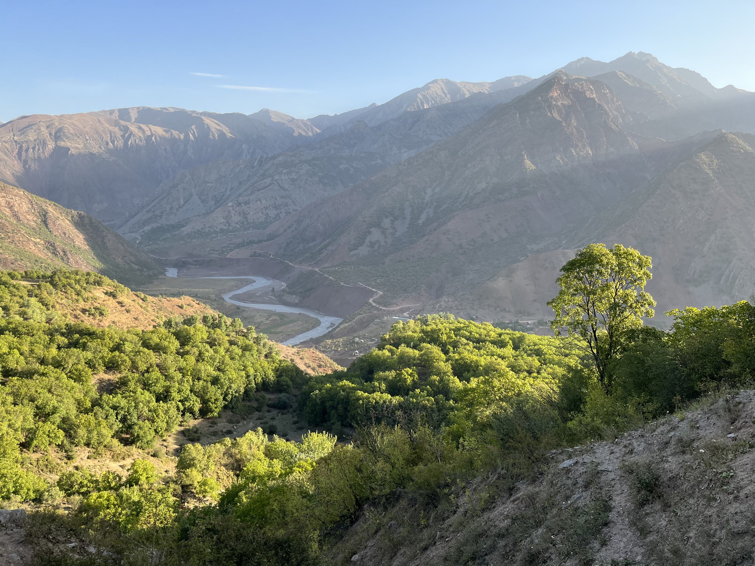
Bureaucratic and law enforcement difficulties: You do not need any permits. You do not need the GBAO permit, as this trek is entirely in the province of Khatlon, and the “Districts under Tajikistan Central Government Jurisdiction“ at the beginning, not GBAO. You are nowhere near a border. But this does not guarantee anything in this part of Tajikistan. In eastern Khatlon province I have been document checked six times over a dozen or so trips (versus zero times in a hundred trips in western Khatlon). I’ve never been detained or threatened, just delayed and annoyed. In bigger towns and at road checkpoints is where this has occurred (plus once at a hotel), and zero times out in nature.
Photos below: plenty of water along the Vakhsh River.

Direction: East to west. Starting in the east allows you to do the highest elevations first while it is still warm, and then work your way down in elevation as you head west in the later fall season.
When?: If you have good tolerance to warm temperatures, then you can hike starting in the first week of September. A mid-September start for everybody else. Summer is too hot, spring has too much rain and mud. The latest start time would be late October.
Time required: I can’t say at the moment, but perhaps 4-6 weeks for the average thru-hiker, less for a fast thru-hiker and longer for the more casual hiker who doesn’t want to hike non-stop all day.
Photo below: foothills above the town of Levakant.

Alternate Spring Season Hike
In the spring you can only do the western section of the trail (between Levakant and Norak). The eastern sections will still have snow up high and some extreme flooding and heavy rains.
In springtime, the small city of Norak will be where you are starting or ending if you want to do the entire western half of the Bactrian Trail. If you are planning to end in Norak after hiking from the western starting point, then the riverside village of Ghirdob on the upper Vahksh River will be where you leave the trail. From Ghirdob you continue up the river on goat/sheep trails until reaching the village of Daldakhuron. From this village you can continue on the same side of the river, or cross the footbridge to the other side. Both sides will take you to the city of Norak, where everything you need awaits you (restaurants, hotels, onward transportation, etc.). We recommend taking a taxi for the road section between Norak and Daldakhuron.
From Norak you can find a spot in a shared taxi to Dushanbe for 20-25 Somoni per seat (2018 prices. 2025 may be as much as 50). The drive is about 90 minutes and you get dropped off at a car station on the eastern outskirts of Dushanbe.
In spring you will have lots of beautiful green grass and spring flowers at various elevations. But you will also have regular rain. And when the grass is green the sheep are grazing in large numbers. This is when you have the highest chance of encountering sheep guardian dogs.

Practical information
Accommodation: Your tent, most of the time. Hotels and guesthouses are available along the main route from east to west in Gharm, Tavildara, Hazrati Sulton, Shaydon (Sari Khosor), Baljuvon, Levakant, and perhaps in these locations: Havzi Kabud, Mullokoni, Sebiston and Kokhi RS. None of these places are likely to speak any English at all, wifi is non-existent in most places, and you will likely be the first foreigner they meet who is not an NGO employee traveling with locals. See section descriptions for more information. You will likely be invited into people’s homes to stay the night or have tea and a meal. In areas with electricity, they are always happy to let you charge your phone/batteries (but in the fall there is electricity rationing, more info below). If you are a Muslim male you can sleep in the small village mosques. As a non-Muslim male traveling solo or with local freinds I was also invited to sleep in mosques. From experience, you don’t last long in the mosque before someone invites you to their home.
Gear: fall is a dry season in southern Tajikistan, but that is not so much of a guarantee with the erratic weather patterns in this region in recent years. Tent choice is not important. You can definitely get away with leaving the tent at home and instead tarp camping or having a small or emergency bivy in case it does rain. You can cowboy camp most nights. Biting insects are almost non-existent in the fall in this area. But curious dogs, wolves, pigs or bears may want to inspect a sleeping cowboy camper at night. So a tent does reduce the chances of that.
I am a fan of sleeping on inflatable air mats, especially when it’s really cold or when every surface is rocky. But along this route there are lots of woody plants that leave sharp pointy stems in the ground, and in a few areas there are thorns that drop from trees and lay waiting on the ground. You’ll probably puncture your air mattress (as I did almost immediately on a camping trip here a decade ago). A closed cell foam mattress/pad is the best choice for the Bactrian Trail. It’s easy to find soft dirt, sand or grass surfaces here. I’m comfortable enough on a cheap old foam pad. Also, the temperatures won’t be cold enough to need an air mattress for the insulating factor.
For clothing, I personally would skip insulating base layers, rain pants and gloves (sun gloves are good enough). I would have a light mid-layer (like a fleece hoody), and skip the insulating jacket (“puffy“). An emergency disposable rain poncho (or a cheap ultralight rain jacket like Frogg Toggs) is good enough if you want to leave the rain jacket at home. The lighter you go with clothing, the more you will want to skip camping at the highest altitudes (this is easy to avoid).
For footwear, you can do this route in trail runner shoes if your feet are in good condition. There will be some rough ground and steep slopes, so if you don’t know if your feet are ready, then go up a level to hiking shoes or boots. For the exact type of trail running shoes, you will need to choose between one with a goretex waterproof layer, or a shoe that is just mesh. Without the waterproof layer, the plentiful dust will collect in your shoes and socks and you will need to be often emptying your shoes and shaking out your socks - with dust on your feet almost permanently. With the waterproof layer your shoes will keep out the fine small dust, but they will collect water (over the top) and not dry out as well as the shoes that just have mesh panels. This will leave you with wet feet for much longer in the sections where you are often walking through a creek. So choose: dusty feet or wet feet. Either way, bring lots of socks.
Food: No section is too long between village grocery stores and bazaars for you to run out of food. In many locations we never bothered to add bazaars and grocery stores to the map, as we are all Tajik-speakers and have no problems finding them (or a village bread-seller in the very small villages). But the type of food may be a problem: you will have to settle for eating lots of bread and instant noodles. Nowhere will have granola, energy bars, peanut butter, instant rice, couscous, or typical European/American trekking fare for sale.
Water treatment: this area is full of livestock, dogs, shepherds, villagers and agriculture. I use a filter and then add a chemical treatment as well if I’m suspicious of the water source. Don’t use chemical treatment alone. With the livestock and dogs, cryptosporidium is a concern, and you need to filter for that. I don’t filter or treat spring water.
You will need to carry extra bottles in some sections. I suggest two 1.5 liter bottles. If you get desperate, just wander into a village or shepherd camp and wave your empty water bottle. The local men and boys will help you out. The same works on roads - wave an empty bottle at passing cars.
Foraging: If you start in early or mid-September, you will be able to eat lots of fruit in the eastern sections: mulberry season will be long finished, but you will find fall-harvest fruits like wild plums, dulona (hawthorns), apples, pears, berries and other fruit growing semi-wild. These are either wild fruit or abandoned orchards left to grow wild. Obviously ask for permission if the fruit is in a village, next to somebody’s house, or in an orchard that looks attended to (usually surrounded by a goat-proof fence.) By late September walnuts are ready. Don’t try to get the nut out of the fruit yourself, you will end up with black hands (the stains may last months). Almost every walnut tree belongs to someone who will come harvest them. Wait for a local to give you some. The western sections have pistachio trees. These also all belong to somebody. Don’t help yourself. If people are picking nuts, I’ve never walked by without being offered a free bag full.
Battery and navigation: You will be following a GPS track. So you need to regularly check your position on your phone, as the trails often fork, and in some locations you will be moving over open terrain from one point to another. Plus you will be taking photos/videos. Buy an extra large external battery pack to charge your phone (20,000mAh minimum). Hotel stops will be required to charge your batteries. Battery charging may be a challenge. At some point in late September (it varies from year to year) electricity rationing starts in rural districts. In these areas, electricity is generally available a few hours in the morning and a few hours in the evening. This is obviously not very conducive to charging electronics and battery packs. Anybody doing an exploratory hike may want to consider 40,000mAh of battery packs. The eventual completion of a new hydroelectric dam may result in more electricity in rural areas. For now, to make the most of your battery charging opportunities, you should bring a fast 30W charger (Euro plug is used here) and a USB-C to USB-C cable to charge your power bank, and using a cable that supports 30W charging.
Paper maps?: You can find old Soviet topographical maps down to the 1:100,000 scale. Much of the information on these maps is very out of date (and not in English). But a bigger problem is that the terrain in the south is not “dramatic” enough to navigate with a 1:100,000 map. The few sections of 1:50,000 scale Soviet maps in this area are of very poor image quality. You can print your own maps online (but those are only as good as the Open Street Map data that they all rely on).
Photo below: Some parts of the trail are rarely traveled, while other sections are used regularly by shepherds and their flocks, firewood gatherers, pistachio harvesters, wild animals, and local travelers.

That’s the main description. If you want to do an exploratory hike, contact me for a rough/beta GPS track, waypoints and extra instructions. I’m not “gatekeeping“ the GPS track, anyone who asks will get it. I just don’t want it to be re-uploaded and passed on elsewhere without all the warnings that are needed when considering an exploratory hike in a region like this. Use Instagram to contact.
What kind of hiker would this be suitable for? Speaking Russian and/or Tajik will be a big advantage, but it’s not a deal-breaker. Download an off-line translator onto your phone and plan well ahead of time. As for skill level, anybody who has done a long distance thru-hike and who can do some minor scrambling and off-trail navigation could manage this route.